Polar bear attacks hiker

pulled from his tent and attacked by a polar bear in Torngat Mountains National Park in northern Labrador.

staticmap

Matt Dyer, a lawyer from Maine, was badly injured during the attack at around 1:30 a.m. AT on July 24. …

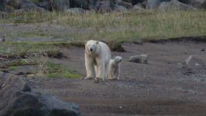
The bear ripped through the electric fence the group had set up around their campsite that night.

When the campers realized what was happening, they acted quickly and fired flares to try to scare the bear away. …

nl-300-polar-bears-20130816

Parks Canada strongly advises visitors to hire an armed bear guard during their stay, but it is not mandatory.

The Inuit bear guards are hired through the Nunatsiavut base camp set up within the park.

However, Castaneda-Mendez said his group was never offered the armed bear guard, and said that the outfitter they hired insisted it was not necessary. He said his group was under the impression the portable electric fence was an adequate deterrent. …

CBC

related – Polar bear attack survivor played dead to save his life

Yukon’s Peel river watershed

The northern Yukon’s vast Peel watershed, with its eight premiere navigable rivers, offers some of the finest wilderness paddling and hiking in the world – a claim we have no hesitation in making. Still a mystery to most people, this country has a fascinating natural history and human story, which together offer the attentive wilderness traveller an unmatched northern experience. …

Protect the Peel

click for larger version

dzjow spent 6 weeks there this summer. Alone — with plenty of bears and other wildlife.

This slideshow requires JavaScript.

see more & higher resolution photos – dzjow – Protect the Peel & first pics

As a Canadian, I signed the petition to Protect the Peel.

Dientes Circuit trip report

Sebastian Irazuzta via email:

… In 2010 I was inspired by the trek you have posted on Navarino Island in the South of Chile. After some research my wife and I decided to take our Canadian winter vacation to Southern Chile and Argentina and see the wilderness of Navarino Island for ourselves. I have posted a short description along with some photos and videos of this trip on Everytrail. …

That’s an interactive map. Click on the image to see it.

I should mention that the weather was sometimes amazingly harsh.

Despite this, I think it was one of the nicest wilderness treks I have
done. I think you may find this post interesting in that I have
uploaded my GPS tracks for the entire trail. This is something I wish
I had had when I was on the trail myself as some sections were
difficult to navigate by map alone due to bad weather.

Thanks Sebastian!

Check out Dientes information page.

ski up hill – skizee

I saw this on TrailsNet.com.

Skizee:

… It is like a ski – snowboard – skateboard version of the Ridekick. Whereas the Ridekick is a self-propulsion system for bikes, the Skizee does the same thing for skis. …

Click PLAY or watch it on YouTube.

details and links – name

… I’d find some way to run over myself. 🙂

CONGRATS to Tim Park and Jim Maidment from (nearby) Kimberley, B.C. on bringing this fun product.

Iceland – hiking the East coast

Richard Tulloch:

I’m sorry, Tasmania, Swiss Alps, New Zealand and even you, Himalayas. You’ve each just been knocked down one place in my ‘world’s most spectacular hiking destination’ list.

Five days tramping around the ‘Deserted Inlets’ of Iceland’s east coast have shot it to number one in the rankings for scenery, challenging terrain within safe limits and ‘having the place to yourself-ness’. …

read more – ICELAND – hiking with vikings

My hiking guidebook didn’t even mention that part of Iceland. No wonder they had it to themselves.

Richard was a guest of Fifty Degrees North:

Trip Name: Hiking at the End of the World
5 days
Strenuous
Price from: AU$1280

hiking Svartifoss, Iceland

trip report by site editor Rick McCharles

Svartifoss (Black Fall) is a waterfall in Skaftafell … Iceland, and is one of the most popular sights in the park.

It is surrounded by dark lava columns, which give rise to its name. The hexagonal columns were formed inside a lava flow which cooled extremely slowly, giving rise to crystallization. Similar well-known lava formations are seen at the Giant’s Causeway in Northern Ireland, and on the island of Staffa in Scotland. …

After seeing the unique falls, I continued on to the Skaftafellsjökull glacier overlook.

I left a Summit Stone at the base of this sign.

From there you can walk up and alongside the big ice.

It was a tad bit windy, as you may be able to tell from this photo. (I might have been able to BASE jump using just my jacket.)

See more photos from this day hike.

bear trashes plane

From 2009.

… When bush pilot Luke Miller, 28, made an overnight stop at a friend’s hunting lodge in Southwest Alaska … he had no way to know that a large and very dedicated menace would, under cover of night, chew and claw his plane to shreds. …

Alaska Dispatch – An appetite for revenge

Yikes.

more photos

remind me never to hike with Skurka

Andrew Skurka is the world’s greatest hiker, famed already for his 6,875mi Great Western Loop.

That was nothing compared to his most recent achievement.

The Adventure Blog:

…his 4679 mile (7530km) Alaska-Yukon Expedition set a new standard for all others to follow.

The route passed through some of the most remote places in the U.S. and Canada, crossing eight national parks and several mountain ranges in the process. As is typical, Andrew went alone and spent 176 days on the trail hiking, skiing, and rafting his way through the unforgiving wilderness.

Now, his full story is finally being told in the pages of National Geographic Magazine, which will feature Skruka’s adventure in the March issue that will be hitting newsstands soon. …

It was harsh.

Nat Geo already has the article onlineAlaska Yukon Trek

more photos

Check the cool interactive map.

Yukon – Slims River to Kaskawulsh Glacier

Phil Armitage posted an excellent trip report of their 2010 adventures on the Slims West trail, 64km (40mi) return.

Here’s their view from Canada Creek campsite:

… From the campsite at Canada Creek it’s 19km (12 miles) roundtrip, with 1200 meters (3,900 feet) of climbing, to the summit of Observation Mountain.

That doesn’t sound like a particularly strenuous day hike, but there’s Canada Creek to cross (twice, with the second crossing likely be harder than the one on the way out, as the water level rises during the day) and no trail for most of that distance.

The summer days are long at these high latitudes but still, don’t underestimate the time required. Most of the parties we met found the hike to be harder and longer than they had anticipated. …

read more – hiking the slims river west trail to the kaskawulsh glacier overlook on observation mountain

Their photos are STUNNING.

… On my trip I never made it past the first creek crossing.

Route finding is tricky. You might need gills to cross some streams in flood. And know that there’s been at least one hiker killed by bear there. Parks Canada shuts it down when the bears are sighted.

Phil recommends special footwear for the water and mud.

THE Definitive Guide to Hiking Torres del Paine

With a title like that, how could I not click.

ADAM SEPER:

A big part of our RTW trip, particularly in South America, was built around hiking and trekking. We hiked the Inca Trail to Machu Picchu, Colca Canyon in Peru, and various hikes in and around El Chalten. All were in preparation for our biggest trek yet, hiking the “W” in Parque Nacional Torres del Paine (TDP) in the Patagonia region of Chile.

In addition to being drop dead gorgeous, one of the other main appeals of hiking in TDP is that all hikers and trekkers can do it independently if they want. Sure, you can sign on with an expensive tour, but it’s unnecessary. Going at it without a guided tour is highly recommended so you can go at your own pace, take the route that’s right for you, and have a multitude of choices along the way. …

click through for more – Traveling Around the World for Couples

Related Posts linked from the bottom of that article:

A Trekking Guide (for those who like to eat and drink a lot)

Trekking Torres del Paine-Which Route to Take

Trekking Torres del Paine-What to Pack

Trekking Torres del Paine-Where to Sleep

Trekking Torres del Paine-Transportation, Admission, and Costs
Chile

There’s more to come.

That really is the most up-to-date guide for independent trekkers. Many are scared off making the long trip south due to lack of details on our Paine information page.

Thanks Adam.