Photodiary of a Nomad in Canada

I’ve been following Photodiary of a Nomad for years.

This couple have documented 6200km+ of walks and over 12000 photos.

Summer 2012 they started on the Pacific Coast, worked their way through the Rockies, and finished amongst the magnificent colours of the eastern forests in autumn:

Prologue

West Coast Trail (Gordon River to Walbran Creek)

West Coast Trail (Walbran Creek to Pachena Bay)

Vancouver Urban Fringe Walk

Skyline Trail – Jasper National Park

The Icefields Parkway

Assiniboine Day-Walks

Assiniboine-Sunshine Meadows Trail

Banff National Park (Two Teahouses and Larch Valley Hikes)

Yoho National Park (Iceline Trail and Lake O’Hara Circuit)

A Tale of Two Cities (Montreal and Quebec City)

Mont Tremblant by foot and canoe

La Mauricie National Park

Saguenay Fiord Trail

Hopewell Rocks (Big Tide in the Bay of Fundy)

Cape Breton Highlands National Park

Wanderings in New Brunswick

Canada page

Not all of those trip reports are live yet. They are still being uploaded.

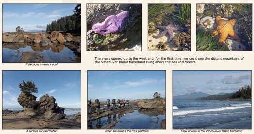
They walked our #1 hike in the world, the West Coast Trail.

Their words — never before spoken — about the WCT:

… The clear morning skies were becoming a bit monotonous, as dawn arrived with a pink glow on the eastern horizon. …

That’s a great trip report for anyone planning for the West Coast of Vancouver Island. In fact, I’m hoping to get back again summer 2013. 🙂

related – some of their best photos from past trips around the world

Into The Mind – Official Teaser

Wow. This looks to be a breakthrough in outdoor film editing.

What drives us to overcome challenge? How do we justify risk? What forces are at the core of a mountain addiction? Unique athlete segments over a multitude of … sport genres

… never seen before moments. Explore how we begin our perception of self, construct the foundations of confidence, and are ultimately led up the path of self-actualization.

As Buddha once said, “The mind is everything. What you think you become.” …

Presented by The North Face – COMING FALL 2013

Click PLAY or watch it on Vimeo.

Alpenwild – Swiss Alps Haute Route

Our #1 trek in the Swiss Alps is the Haute Route Chamonis – Zermatt.

Click PLAY or watch it on YouTube.

Alpenwild is by far the largest tour operator leading the classic trek

They’ll have at least 11 guided groups summer 2013 and assist hundreds of self-guided clients.

They offer three different guided itineraries.

A typical price for a self-guided Haute Route in 2013 will be about $1800. The increase is largely due to the drop in the US$ against the Swiss Franc since 2009.

alpenwild.com

That’s a life changer. I did it independently in 2009. That’s tricky. With the self-guided option all transportation and accommodation is organized for you.

Swiss Alps: Andermatt on foot

Walk any which way from the centre of Andermatt and you will find yourself inundated by scenes of natural beauty and air so fresh it should be bottled.

… the Gotthard Area, in which Andermatt lies, is home to over forty lakes, both large and small, which are crystal clear and rich in fish. As such, there is a 85km long footpath in the Goschenen Valley which is dedicated to the discovery of these pools. For the ultimate water-themed trail however, the Four Sources walk, which begins by the Oberalp Lake, can take up to five days and will lead you to the sources of the Rhine, Reuss, Ticino and Rhone rivers. …

read more on THE MAKING OF ANDERMATT

There’s a nice video on that page showing off the region.

NEW – world’s highest national park

The world’s highest national park, the Qomolangma National Park, located on the border of China and Nepal with a total area of 78,000 square kilometers has been inaugurated.

The park includes five mountain peaks with altitudes of more than 8,000 meters

Qomolangma is Tibet’s third national park after the Namtso National Park, which was recently inaugurated near a holy lake for Tibetan Buddhist pilgrims, and the Yarlung Zangbo Grand Canyon National Park that opened in 2010.

The parks are part of the Tibetan efforts to turn the region into “an important world destination.” …

Press TV

Actually, not much has improved for the independent hiker in Tibet since I was there late 1990s.

Don’t go — unless you are willing to sign on to an expensive and often frustrating group tour. Or are willing to trek “illegally”, as we did.

Support Nepal instead.

(via National Parks Traveler)

related – Seven Tibetans Self-Immolate This Week

At least 62 Tibetans have lit themselves on fire since 2009 in protest of Chinese rule in Tibet.

7 gorgeous Korean mountain hikes

My only hike in Korea was the new coast island adventure — Jeju Olle.

I’ve got to get back for the mountains.

… Korea was blessed with a shapely topography: 70 percent of its landscape is mountain (the other 30 percent, expensive coffeeshops).

Around this time of year, due to the startling colors of the curvy landscape, the trails will doubtlessly be packed with streams of hikers in garish colored hiking gear …

But there are also many paths to the top of the mountain (literally), and many excellent paths that don’t necessarily lead to the top.

Here’s where to check out the most vibrant autumnal hues or, later in the year, the bleached landscape of a snowy mountaintop. …

1. Seoraksan
2. Bukhansan
3. Taebaeksan
4. Songnisan
5. Jirisan
6. Naejangsan
7. Hallasan

Seoraksan National Park

CNN

Jackson Circuit, Wyoming

Wyatt Roscoe from Jackson, Wyoming, conceived a grand tour.

Solo by bike, packraft and on foot.

Immaculate Chaos – Circumnavigation of Jackson

Click through. Those are some amazing stories and photos.

Jackson is a major gateway for millions of tourists visiting nearby Grand Teton National Park, Yellowstone National Park, and the National Elk Refuge.

I saw this linked from Hiking in Finland.

Nepal – Lake Tilicho, Nar and Phu

… News reporter and anchor Erick Thompson and writer Erin Trainer joined a group of trekkers from Vancouver Island for a three week trek in Nepal.

In addition to hiking along the Annapurna Circuit, the group visited the world’s highest lake (Lake Tilicho) and the mythical valleys of Nar and Phu. …

… Quadra Island-based trekking guide Mick Bromley … has led dozens of treks in various countries but Nepal remains his first love.

Click PLAY or watch it on YouTube.

part 2

part 3

part 4

Desolation Wilderness – Bayview to Echo

trip report by site editor Rick McCharles

In 2008 I linked to John Fedac’s Tahoe Rim trip report:

… Hands down the best TRT leg is the 35 miles between Barker Pass to Echo Lake in the Desolation Wilderness over Dicks Pass. (With a side trip to summit Mt Tallac for its unparalleled Tahoe view) …

This summer I finally got the chance to walk a couple of days out of Tahoe myself.

Desolation Wilderness is a 63,690-acre (257.7 km2) federally protected wilderness area located along the crest of the Sierra Nevada mountain range, just southwest of Lake Tahoe …

… a popular backpacking destination, with much barren rocky terrain at the edge of the tree line: it has extensive areas of bare granite. …

Fedak and I dropped my vehicle at the Echo Lakes Trailhead. Then he drove me to pay for my overnight Wilderness Permit.

Finally, after some consideration of how much time I had, he recommended I start at Bayview trailhead.

climbing up out of Bayview

The weather was terrific, so, the day I was there, everyone was scrambling Dick’s Peak as a side trip.

Rick on Dicks

I left a Summit Stone.

The view was terrific. But I spent most of my time trying to capture photos of the dozens of butterflies blown up top.

I camped that night at Gilmore Lake campground for easy access to Mt Tallac. The lake is only 1400ft (427m) below the summit.

I sprinted that ascent, in any case, early next morning … pursued by hordes of mosquitoes.

vista over Lake Tahoe from Tallac

Mosquitoes are bad here. At some lakes. Some times. I got a bit unlucky. These were the first mosquitoes I’ve ever seen during many hiking trips in California.

Fedak had warned me. So I had a head net.

The highlight of my trip was the section passing Lake Aloha, a stunning glacier carved granite basin.

Here’s Pyramid Peak, the highest point in Desolation.

I finished here at Echo Lakes Trailhead.

A superb day hike is catching the boat. Romping around Aloha. And returning same day, either catching the boat back to your vehicle … Or walking the last bit, time and energy allowing.

See the rest of my photos from this 2 day hike.

Thanks John Fedak. 🙂

Check his annotated photo trip reports at Fedak.net.