Llama trekking in the Alps

Mellow mountain walking. But be careful not to get a stream of llama spit in the eye while on a narrow trail.

The Eagle Way is a 1,480km trail through some of Europe’s most heart-stoppingly glorious scenery: distant clutches of chalets and spires engulfed by manicured, velvety meadows, verdant hillsides veined with tumbling glacial brooks and iridescent bursts of midsummer Alpine flora. And above it all a rearing backdrop of jagged, piebald peaks, among them Austria’s highest, the mighty Grossglockner. The sky was huge and blue, the air as crisp as apple strudel; it could not have been more Sound of Music. High on the hill with a lonely Guy-herd. …

read the article – Stick your neck out, Llama trekking in the Tyrol may sound like a joke but it’s seriously good fun, says Tim Moore -The Guardian

lamatimmoorex4.jpg
Tim and his new friend go for a stroll in the Alps. Photograph: Jan Erik Burger

Dolomiten Lama Trekking … dolomitenlama@aon.at) runs three day llama treks with half-board accommodation in mountain huts from €240pp for a group of seven minimum. Day trips from €38pp.

$40k prize money – climb Mt Washington, NH

Where do I sign up for the Seek the Peak fundraiser for the Mount Washington Observatory?

I could handle the media interview at the top:

mt-washington.jpg
larger version

… Hikers came in droves to support the non-profit Mount Washington Observatory during Saturday’s annual Seek the Peak hike-a-thon, making the 2008 edition the most successful event in its eight-year history. 250 hikers from as far away as Texas, Colorado, Florida and the Carolinas, ventured to the summit of the tallest peak in New England, raising a total of $97,000 for the Observatory. That sum fell just short of the event’s ambitious $100,000 goal, but surpassed the event’s 2007 fundraising totals by more than $33,000 and more than doubled the 2006 effort.

Despite its reputation for being home to some of the most extreme conditions on Earth, Mount Washington was rather tame on Saturday, with sunny skies and pleasant hiking conditions. This was a welcome sight, after a week’s worth of torrential downpours and strong thunderstorms in the area.

Presented by Subaru and L.L.Bean, Seek the Peak is Mount Washington Observatory’s largest annual fundraiser. All proceeds from the event benefit the 76-year old organization’s ongoing efforts in weather observation, education and research. The cumulative total that this specific event has raised over its eight year history is now over $377,000. …

Mt Washington Observatory

Seek the Peak – official site of the fundraiser

unrelated post: walk up, ride down – Mt Washington, B.C.

hike the Forbidden Plateau, B.C.

Easiest access to Strathcona Provincial Park on Vancouver Island.

I finally found the time to hike this very popular destination, only 1hr from my parents house in Parksville, B.C.

… The gently sloping sub-alpine terrain is broken by small, rugged hills and pitted with small lakes. Much of it is contained within Strathcona Provincial Park, and a network of trails facilitate hiking, cross country skiing, and access to Mount Albert Edward.

wikipedia – Forbidden Plateau

Highlights include lakes and alpine meadows (former lakes). In fact, the most popular trailhead is Paradise Meadows at Mount Washington Alpine Resort ski hill. Most famous for ski and mountain bike trails, the Forbidden Plateau draws thousands of hikers each year, as well.

I camped at Circlet Lake. This is the best campground basecamp for those who plan to scramble off-trail routes in Strathcona. (The most popular being Albert Edward and Castle Crag.)

I feared the trails would be tree locked. Not so. The views are quite open. It’s consistently pretty. A section close to the ski resort is even wheelchair accessible. There are good options here for hikers of all ability levels.

See the rest of my annotated photos on flickr – hiking Forbidden Plateau, B.C.

related post: walk up, ride down – Mt Washington, B.C.

walk up, ride down – Mt Washington, B.C.

I had a great half day on Vancouver Island. (Not at the much more famous Mt Washington in New Hampshire.)

Mt Washington is the home of the excellent Mount Washington Alpine Resort. It’s 25km from the Comox Valley, close to good hostels in Courtenay.

In summer the chair lift carries hikers and bikers. The view from the top is awesome.

The real highlight are the cheeky ‘Whiskey Jacks’ (Gray Jays) who happily alight on your hand, hoping for crumbs. (Don’t feed them.)

If you climb the mountain (45min) you can ride down for free. Otherwise, a trip is a reasonable $15.

Highly recommended.

more photos – flickr

Nearby is Paradise Meadows Trailhead, the best jumping off point for hiking the Forbidden Plateau. This is also the most popular trailhead of all in massive Strathcona Provincial Park.

Overland Track in winter – snow in Oz?

Another excellent post on Our Hiking Blog shares a very cool adventure. They reposted Nick’s pics of a winter tramp on the most famous hiking route in Australia:

overland-winter.jpg

pelion-hut-winter.jpg
Pelion Hut in winter

See more photos – Winter in Tasmania – Snow on the Arm River and Overland Track

Here’s how the same gorgeous alpine hut looks in summer:

pelion-hut.jpg
Pelion Hut in summer. (from our February 2007 trip report)

Looking for an excuse to hike Australia? Check our Overland Track information page. It’s one of our top 10 hikes in the world.

Tahoe Rim Trail in September

Tom Mangan on Two-Heel Drive posted a great overview on the famed California loop trail.

I’m looking at perhaps a week on the trail finishing Sept. 20th, 2008.

The Tahoe Rim Trail is a 165-mile (266 km) long-distance hiking trail which forms a loop around Lake Tahoe in the Sierra Nevada and Carson ranges of California and Nevada in the United States. The trail ranges in elevation from 6,240 feet (1,900 m) at the outlet of Lake Tahoe to 10,338 feet (3,151 m) at Relay Peak in Nevada. About 50 miles (80 km) of trail above the lake’s west shore are also part of the much longer Pacific Crest Trail. …

The main hiking season is usually from July through September, though lingering snow patches may sometimes be found into August of high snow years. The trail is open year-round, but is not marked for winter use. The climate is typical of the Sierras, with severe storms during the winter and almost no precipitation falling in the summer.

… Hikers must obtain permits before entering the very popular Desolation Wilderness area southwest of the lake.

Wikipedia

Tom recommended this guidebook.

A Complete Guide for Hikers, Mountain Bikers, and Equestrians

Wilderness Press The Tahoe Rim Trail: A Complete Guide for Hikers, Mountain Bikers, and Equestrians

I’ll pick it up to plan my itinerary.

hike Yukon and Alaska – the Chilkoot Trail

They are celebrating at Happy Camp every night this time of year. It’s high season.

If you’ve never been, check this trip report / article and photos from guru Peter Potterfield on Great Outdoors:

The rocky slope is dusted with light snow and coated with freezing rain. I take one more big step—slowly and carefully–and then another. Here, on the steepest part of this storied route, the next step is the only one that matters. These are the so called Golden Stairs leading to Chilkoot Pass, and a similar caution must have been the mantra of hardy miners who plied this cruel slope in 1898. Here, the most trying section of the long ascent climbs steeply up past the “Scales,” the historic rocky ledge where miners had to prove they carried the requisite weight of equipment and supplies to pass muster with the Mounties.

stream-crossing.jpg

Both sides of the trail are littered with rusting relics, equipment the miners jettisoned out of exhaustion. Even today, the offal of their back-breaking burdens remains, strewn along the way, giving the trail an authentic aroma of human struggle. But these treasure seekers weren’t the first to use this great trail. One of the few glacier-free corridors through the intimidating Coast Range of British Columbia, the Yukon and Alaska, the Chilkoot Pass had for centuries been a crucial trade route for the native peoples of the coast. And now it remains one of the most interesting backcountry routes in North America. …

Hiking Historic Chilkoot Pass

Want to go?

Check our information page on The Chilkoot Trail – besthike.com

chilkoot3-1.jpg

trekking in Darjeeling Hills and Sikkim

An excellent Himalayan hiking option in Northern India:

… Although Sikkim is only 65 miles long and 45 miles broad, yet it contains some fo the finest mountain and ravine scenery in the world. The Kanchenjunga range is viewed in all its splendour, while the Everest massif can be seen from many advantageous points. …

sikkim.jpg
Sikkim (in orange)

The jumping off point for Sikkim is Darjeeling. Several hikes are recommended:

1. TO PHALUT AND BACK
2. TO PAHLUT AND RETURN via JHEPI
3. PHALUT AND PEMIONGCHI

Number 3 sounds great:

… The march, though long has few equals in the variety and beauty of the scenery that is met with. Leaving Phalut the road takes a short climb to the Singalila Ridge (12, 200 feet at Singalila Point) along which it travels for 3 miles. The grassy, boulder strewn mountain side, gay with flowers, and with the snows always in view, presents a pretty picture. Plunging downwards for 11 miles the road drops 8,000 feet, passing through a variety of vegetation shortly how cold it is up in Phalut, at the start of the march, it is very warm in Dentam. There is a small bazaar in the neighbourhood.

The climb to Pemiongchi, 6,920 feet, begins with the next day’s trek. The 11 miles march is enlivened by some very beautiful scenery, including scenery, including cascading waterfalls and gorgeous orchids. The full beauty of the Sikkim forests strikes one during the march to Pemiongchi.

Pemionngchi is remarkable for its monastery and different angle at which Kanchenjunga is viewed. The monastery of Sanga Choling is the older and largest in Sikkim and it means “The Sublime Perfect Lotus”. A beautiful view of the surrounding country-side can be obtained from the monastery and it is itself of great interest.

The return journey is via Rimchenpong (6,300 ft), Chakung (5,100 ft) and Badamtam (2,500 ft). The route however, can be shortened by 1 day by making a double march of 20 miles from Chakung direct to Darjeeling via Singla, Barnesbeg and Takvar Tea Estates. …

read more – Hot Stimulating Treks and Tours

kanchendzonga.jpg
original – flickr – Gateway to Singalila National Park – Kanchendzonga

Singalila National Park – Wikipedia

public transport to best hike trailheads

Do you hate parking a rental car at the trailhead?

glacier-wiki.jpgThanks JTownshend for pointing us to a website which clearly explains transportation options from my home town — Calgary, Alberta, Canada — to Waterton National Park on the U.S. border.

Why is this such valuable information?

Because that’s how you can most easily access our #6) best hike in the world: Glacier North Circle, Montana, USA, at least from Canada.

If you do not have your own vehicle, here’s how to get to one of the trailheads from the Calgary airport:

calgary-waterton.jpg

Airport Shuttle ExpressCalgary to Waterton

(I’d skip the airport taxi, instead taking the public bus downtown for $2.50.)

If you have not yet decided on what BIG hike to do this summer, consider the North Circle. It’s awesome.

And — as a bonus — out of Calgary you could add our #5 best hike in the world — Sunshine to Assiniboine — in the Canadian Rockies. No personal vehicle needed for that adventure either, assuming you start and finish at the Sunshine Village trailhead.

Another great option is our #2) best hike in the world — the John Muir Trail, in California.

hiking in Taiwan

I’m scheduled to take a trip to Cambodia in July. (A volunteer position working with sport coaches there.)

It’s too hot and humid in summer for hiking, I fear. But what if I stopped over in Taiwan on the return? What are the best hikes there?

RESEARCH:

taiwan1.jpg

… the island is covered with remote and beautiful mountains, which are laced with hundreds of hiking trails. These are the emerald peaks that visitors see from their plane windows, just before they descend into a factory city on the west coast.

Taiwan is home to the highest mountain in east Asia – at 3,952 meters Yushan (Jade mountain), is taller than Japan’s Mt. Fuji – while dozens of peaks soar above 3,000 meters. Protected by national parks, and home to black bears, salmon, rare birds and other wildlife, the mountains are Taiwan’s most compelling attraction.

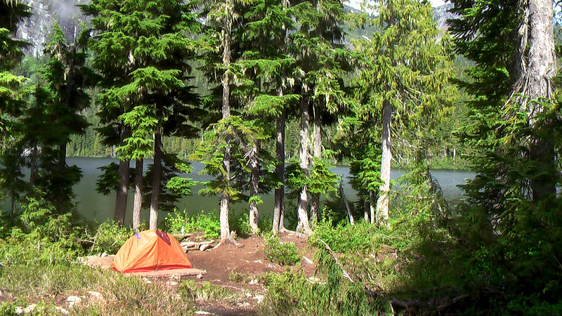
Trekking in Taiwan is not for the faint-hearted. The Central Mountain Range is steep and wild, and much of it is covered with thick forest. Summer thunderstorms rise unseen, temperatures can drop below zero, and facilities are few and far between. But for those willing to carry their own gear, the treks are among the most beautiful in Asia.

The top hikes in Taiwan – Chilai Ridge and Yushan – require a reasonable level of fitness and the proper equipment, which includes a tent and stove, food and water, a sleeping bag, good boots, and warm clothes.

To really get away from it all, try the Chilai Ridge trail, a rugged walk straight down the mountainous spine of Taiwan. The trail begins at Ho Huan Shan hostel, on the northern cross-island highway (#14) about 60 kilometers from Puli.

From the hostel, it takes four hours and a lot of legwork to reach the 3,200-meter summit of Chilai Ridge. The ridge trail then proceeds due south, over a succession of rocky outcrops that is regarded as the most dangerous trekking walk in Taiwan, but one that is unrivalled in beauty. In some places the ridge is sharp as a knife, with cliffs on either side, and it is composed of leaves of shale that crumble underfoot like rotten cake. …

Out of Thick Air: Taiwan’s Mountain Highs – Time magazine – BRENT HANNON

Sadly, in the end, my flight was routed via Hong Kong instead.

Hmmm. Perhaps I should do one of the big urban hikes while in transit.