Torres del Paine Circuit trek, Chile


Hank Leukart posted a magazine quality essay on one of our top treks in the World, the Paine Circuit.

Adopted by Kiwis in Chilean Patagonia. How to hike the Torres del Paine Circuit on someone else’s family vacation

… The only thing standing between us and views of 270-square-kilometer Glaciar Grey was Paso John Garner, a steep and rocky pass through the Patagonian Andes Mountains. My brother Brian and I looked up nervously at the severe mountain crags and glacial ice surrounding us, and though we hadn’t been able to substantiate the rumors of a lost hiker’s death during a blizzard in the pass three days before, the gossip made us uneasy. We knew that some hikers had turned back, failing to conquer the pass due to dangerous weather. …

glaciar-grey

read the 3-part series article on Without Baggage

Especially if you want to find out why Hank decided to climb on to an iceberg.

hank

related posts – more Without Baggage trip reports

backpacking the John Muir Trail

An entertaining 6min HD video by Pete Bell.

… an end to end hike of the JMT this past summer. It features 5 high school students from Chapel Hill, NC and their experience along the trail. We took 16 days at about 15 miles of hiking per day to hike all 220 miles from Yosemite Valley south to Mt. Whitney. We had one resupply at Vermilion Resort where the group cleaned out the small store there trying to stock up with 9 days of food.

It includes one bear encounter.

Vodpod videos no longer available.

BestHike JMT information page.

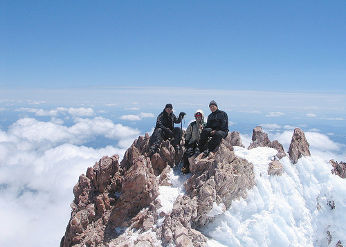
climbing Mt Shasta, California


Friends tell me this is the best climb in CA. May – July.

summit-shasta
larger version – flickr – Darcy McCarty

And that it’s quite doable for a non-mountaineer.

The The Mozmonkey Blog is planning for summer 2009, as well:

… Typically the climb and decent will take two days, although, some people do it in one.

Day 1 starts with a 4 – 6 hour hike from the parking lot up to Helen Lake (which is really just a glacier) where you setup base camp. The rest of the day is spent admiring the view, making food (yay, dehydrated meals!) and preparing your day pack for the next morning.

The summit ascent begins somewhere between 12 AM – 3 AM the next morning. You’ll want to start super early while the snow is still firm and solid and get to red banks before the sun starts making it soft and slushy.

When you reach the summit stop to enjoy the view, regain your energy and prepare for the best part of the journey — glissading down the mountain! This literally means you will sit on your butt in the groove created by the people before you and slide down the entire mountain; stopping briefly at base camp to collect the rest of your gear. Not to worry, you will have an ice axe with you as a safety device that will help you regulate your speed down the mountain.

So that’s it, 2 days to get to the top and and 3 – 4 hours down. …

Climbing Mount Shasta

more photos tagged Shasta on flickr

Sounds something like our climb of Mt Adams, Oregon last year.

South American Explorers


If you trek in South America, you spend a lot of time at the SAE clubhouses in Cuzco and Lima, Peru.

Hikers and mountain climbers rendezvous there to organize trips.

I’m a Facebook friend of the Lima Clubhouse. They offer many special events for international travelers. For example:

trek-south-americaWednesday, January 14, 2009
Location: Lima Clubhouse

Interested in trekking, but have no idea how, where, when, with whom to start? Join us on January 14th for “Trekking in Peru 101”. SAE Lima Clubhouse hosts trekking expert, Virgilio Marmanillo, to answer all your questions and concerns. Virigilio has been guiding trekking and adventure tourism travelers for over 10 years in Peru. He’s an expert in the Salkantay, Inka and Choquehuanca trails.

Stop by and learn tips from a pro, find out what you need for your route, and maybe even start prepping for a trekking adventure!

***cold cerveza for sale!!!!***

Cost: free for all

official website – South American Explorers

I highly recommend you join the SAE if you travel in Peru.

trekking Manaslu and Annapurna, Nepal


Wow. Check out a 39-day mega-trek photo trip report posted by Tubby.

And this is only PART 1 of their adventures in Nepal.

Tubby’s group connected a trek around Manaslu with the Annapurna Circuit. AND the sidetrip to Annapurna Base Camp.

They had wondrous moments. And many challenges.

Here’s the receipt from Maoist rebels for the group “donation”:

rebel.jpg

This extortion is supposed to be ended. But I expect the odd local in Nepal will still be asking for cash for the cause.

As always, the charming people were a highlight:

kids.jpg

I can’t find a way to summarize this monster trip in a short blog post. You need to check it out yourself: Trekking our arses off in Nepal #1

manaslu.jpg
Manaslu

Annapurna Circuit information page.

Annapurna is one of our top 10 hikes in the world.

hike Monkman Provincial Park, B.C.


Bluepeak was the first blog to announce the opening of the Monkman Pass Memorial Trail in Northern British Columbia.

This 63-km long trail follows the route that Alex Monkman and his band of pioneers established in the 1930s. Most of this little-known, but spectacular trail is in Monkman Provincial Park, leading from Kinuseo Falls over the Rocky Mountains to Hobi’s Cabin on the Herrick River. There are very few facilities along the route – this is a true wilderness experience.

The most famous feature is Kinuseo Falls.

waterfall
original – flickr – wgelnaw

Monkman Expeditions can guide you on the new historical trail.

But it looks quite doable for experienced wilderness hikers independently.

Start planning your future adventure. First you have to get there …

map
map

related:

  • map of the Monkman Pass Memorial Trail
  • Monkman Provincial Park – Wikipedia
  • Monkman Provincial Park – official website
  • Tiger Leaping Gorge a best hike?


    It’s on our list of best hikes in Asia.

    tiger-leaping-gorge-map

    It should be one of the best trekking adventures in China.

    But ceaseless Chinese development may have already ruined it. (Though a proposed hydroelectric dam that would have submerged the Gorge was cancelled in 2007.)

    tiger-leaping-gorge
    larger version – flickr – livepine

    Tiger Leaping Gorge (Chinese: 虎跳峡; pinyin: Hǔtiào Xiá) is a canyon on the Yangtze River

    Around 15 km in length, the gorge is located where the river passes between 5,596 metre Jade Dragon Snow Mountain (玉龙雪山; Yùlóngxuĕ Shān) and 5,396 m Haba Xueshan (哈巴山; Hābā Shān) in a series of rapids under steep 2000 metre cliffs. Legend says that in order to escape from a hunter, a tiger jumped across the river at the narrowest point (still 25 metres wide), hence the name. …

    The hiking path (“the high road”) is well-maintained and marked, although sometimes narrow, and is used by the Naxi as part of everyday life. This trail is longer than the lower road, approximately 22 kilometres (14 mi), but more varied, with fantastic scenery—mainly mountain views—a challenge for most but well worth it. It features a surprising variety of microecosystems, waterfalls and a fair number of guesthouses for trekkers. …

    Wikipedia

    I hiked it about 11yrs ago. And it was already too developed for me. By the sounds of the trip reports I’ve read, it’s gotten much worse.

    Someday the Chinese governments will learn to preserve their best wilderness areas. This is part of a World Heritage Site. And yet it’s still threatened.

    Read a positive trip report with photos by Edbo on Shutterfly.

    trek to Mt Tronador, Argentina

    As usual, the best trip report was posted by Photodiary of a Nomad.

    Their 3 day traverse of Nahuel Huapi National Park in Argentina — on an unusual route — without meeting any other hikers on the trail, appeals to me. (They did have a dog or two tag along.)

    … it was hard to decide the highlight – was it the glinting granite slabs of Cerro de las Cristales, the amazing blue of Laguna Azul, the perfect form of the green-clad glacial valleys, the richness of the wetlands, the great vistas of Tronador glistening in the sun – was today better than yesterday? – did it really matter? – tonight we would have some very pleasant dreams.

    Personally, I want to see Mt Tronador.

    tronador.jpg
    larger version – flickr – fainmen

    Check the trip report for yourself: Nahuel Huapi Traverse

    Our besthike Nahuel Huapi Traverse information page.

    Fitz Roy – best mountain vista anywhere

    What do you think?

    fitzroy.jpg

    It’s rare to get this clear a view.

    Photodiary of a Nomad had perfect timing. Lucky ducks!

    From their trip report:

    argentinamapsm.gif

    At 6.30am I looked outside the window of our room; snow still lay on the ground in El Chalten and the hills around, but it was glistening ….. in the sunlight. A fine sunny day is a precious object in this part of the world and there was no time to dally. We were up, showered, fed and on the track by 8am, hoping to catch our first glimpse of the mountains of Fitzroy. With the promise of fine weather, we decided to head up the lesser known track to the the Mirador de Loma de Pliegue Tumbado, with the promise of a magnificent panorama of the two icons of this area – 3120m Cerro Torre and 3405m Monte Fitzroy. …

    It was cloud covered the entire time I was there.

    … Almost on cue, the clouds parted to reveal one of the best alpine panoramas that we have ever seen; the incredibly sharp needle of Cerro Torre and the dark bulk of the south face of Monte Fitzroy standing guard on each side of Glacier Torre, curving down into the milky green waters of Laguna Torre.

    a28080.jpg

    read on – Los Glaciares – Fitzroy Treks (part 1)

    Want to trek there yourself?

    Check our besthike Fitz Roy information page.

    All hikers who travel to Fitz Roy trek nearby Paine, as well.

    another Inca Trail alternative – Moonstone Trek

    First off, this adventure does not have you hiking into Machu Picchu.

    It finishes 7mi away in (amazing) Ollantaytambo. From there you take the train to Aguas Calientes. Then the bus up to the ruins.

    machu-picchu.jpg
    larger version – flickr – FranUlloa

    On the other hand, it does look pretty good compared with the over-popular, problematic Inca Trail.

    It passes through seldom-visited Andean villages, Inca and pre-Inca ruins and heads onto a beautiful altiplano plateau surrounded by glaciated peaks. Most groups won’t encounter any other tourists for the entire trek and the combination of stunning mountain scenery and wildlife, fascinating relics and real isolation is truly rewarding. …

    Supported by horses rather than porters. It’s claimed to be a little tougher than the standard Inca Trail, as “it goes higher and covers slightly more distance”.

    moonstone-altitude-chart.jpg

    Exodus Guide Tours – Moonstone Trek

    lamas.jpg
    larger version – flickr – FranUlloa

    (via The Adventure Blog)

    The best alternative is still Choquequirao to Machu Picchu.