
humerous trip report by site editor Rick McCharles
An attempt to be funny:
My original plan was 45km (27.4mi) return to the Glacier. And perhaps on to the Observation Mountain lookout, camping one night at Canada Creek.
I’d read the official Parks Canada description – A’äy (SLIM’S) WEST TRAIL & ROUTE
Arriving at the Tachàl Dhäl (Tachal Dhal) Information Centre, I was surprised to find it already locked up for the season. Nobody in Whitehorse had warned me about that.
Never mind. … Who needs to get updated on local conditions before setting out on a multi-day hike?
Check the trailhead map. And GO.

Amazing. A super highway through the mountains to the toe of Kaskawulsh Glacier. The elevation gain is less than 100m over 22km.
Within an hour I came upon this memorial to a hiker killed by Grizzly in 1996.

Why didn’t someone warn me there were Grizzlies in Kluane National Park?
… Aren’t the males hungry for a meat feed just before hibernation?
Oops. All this flat tundra is pretty soupy. This was the only boardwalk across the marsh.

Why didn’t someone warn me to bring a second pair of footwear for water?
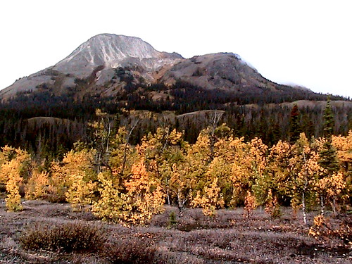
The Autumn scenery was other worldly. I felt lucky to be there on Sept. 11th.

A few hours in I ran into this river crossing:

In the Fall water levels should be very low. … Right?
I backtracked to a ridge and relaxed watching 3 other hikers try to find the best place to cross.

Eventually (tiring of that entertainment) I set up my tent and took an afternoon nap in the bright sunshine.

My Slim’s River hike was over. I wouldn’t make it to the Kaskawulsh Glacier.
Next day I returned to my vehicle early, on to more Yukon adventures.
more photos – hiking Slim’s River West, Yukon (A’äy Chù)

Perhaps you should have registered with Parks in Haines Junction and then you would have known more about the hike? Did you not get your park permit?
I didn’t get the permit. … But I’d checked with the Parks Canada office in Whitehorse. She looked up the opening hours and phoned the visitor centre at the lake. And told me to go there.
Somehow even she didn’t know it was already closed.
So I drove past the Haines Junction office without stopping.
Yup, too bad you didn’t register in Haines Junction.
Must’ve been your first time in the Yukon. Didn’t know there’d be grizzlies? Didn’t know you’d need footwear to do creek crossings? Sounds like poor preparation on your part. The fact that those hikers crossed at the top of Bullion Creek tells me that the water was in fact low, and you were simply not prepared for hiking in Kluane.
I guess I’d better go back and add some smiley emoticons on that post.
My attempt at humour seems to have failed.
… Actually I was exhausted from a 17km leg of the Skagway – Whitehorse relay. And was quite happy not to get my feet wet in the river.