
It was the most shameful act in the history of mountaineering: 40 climbers, including a large number of guides and clients from a team offering climbs for profit, stepped over a dying independent mountaineer en route to summit. On their way down from the top, they stopped and video filmed a chat with the fading climber, for an upcoming documentary.
when can I get to Moab, Utah?
When I hiked in and around Page, Arizona for a week it seemed every local hiker pointed me towards <a href=”Moab, Utah. I’ve never been.
Moab is 233mi (374km) southeast of Salt Lake City. It’s a tiny town that draws mobs of tourists, mostly visitors of the Arches and Canyonlands National Parks.
The town is also famed for mountain bikers who come for Slickrock Trail.
I hope to get there for hiking sometime in 2007.

Delicate Arch
Harvey Manning – dead at 81
The author of dozens of great hiking guides is gone. Rest in peace.
Harvey Manning, an icon of the mountaineering community who helped shape and preserve much of this region’s wilderness, died Sunday at age 81. Manning also wrote dozens of mountaineering and hiking guides, many of which have become classics. Most area outdoors enthusiasts, armchair or otherwise, grew up on one of his “100 Hikes” series of books.
“I feel like one of the great cedars of the North Cascades has fallen,” said Rick McGuire, former president of the Alpine Lakes Protection Society and longtime friend. “It’s hard to sum up a man like Harvey. He was a force of nature.”
Manning, known and beloved for his fearsome directness, was a tireless voice for conserving the forests as well as making them accessible to citizens of the Northwest. …
Harvey Manning, 1925-2006: Author of hiking guides ‘was a force of nature’

the hiker’s satellite phone is (almost) here
Today, satellite phone manufacturer Globalstar just announced the GSP-1700, the company’s smallest satphone to date, weighing just 7.1oz (203gm) and 43 percent smaller by volume. In addition, this Qualcomm handset packs an EV-DO modem, so you can get high-speed data access from “virtually anywhere you can see sky,” according to the company’s website. The GSP-1700 also stays loaded for four hours of talk time and 36 hours of standby time on a single charge. We’re not sure on the price of this handset, but given that its predecessor, the GSP-1600 goes for $750 (without a service plan), it’s a safe bet that this one will go for at least that much when it’s released “in the coming months.”
Globalstar GSP-1700 satphone also loaded with EV-DO – Engadget

book – Lightweight Backpacking and Camping
I signed up with AppalachianTrail.org in anticipation of a trip to Appalachian Trail Days in 2007.
They strongly recommend Lightweight Backpacking and Camping: A Field Guide to Wilderness Equipment, Technique, and Style.
Reading the reader reviews on the Amazon site (always a good idea) comments are somewhat mixed.
But I am IN. It’s added to my “to read” list.
Already a lightweight Backpacker, I’m now simply fine-tuning my kit and food for various hikes. Looks like a perfect resource for me.

new look for the besthike.com blog
Six months is a long time on the web.
It seems much longer since I launched this blog. I used the default theme in WordPress with a modified header image.

I updated in early November, 2006 with these objectives:
So far I am quite happy with the new theme, based on Cutline.
It may look a little strange for a few days. Especially if you use the SAFARI browser. I am still working out a few bugs.
Rick McCharles, editor
if I could walk on water …
… I wouldn’t need a hiking kayak.

Massachusetts inventor Yoav Rosen just received patents for these water walking devices. … Rosen’s company, Wavewalk, specializes in creating water craft that can be used standing up.
Walk the Atlantic – GetOutdoors.com GO Blog
Watch a demonstration on Google Video.
da Vinci forgot to patent it after roughing out the potential prototype.

image – GizMag.com
best of the Canadian Rockies – Emperor Falls
Of many, many highlights hiking Mt. Robson / Berg Lake in the Rockies, getting a shower under majestic Emperor Falls was most special. I’d actually never heard of these Falls before I hiked Mt. Robson. The are the most impressive in Western Canada, I reckon.
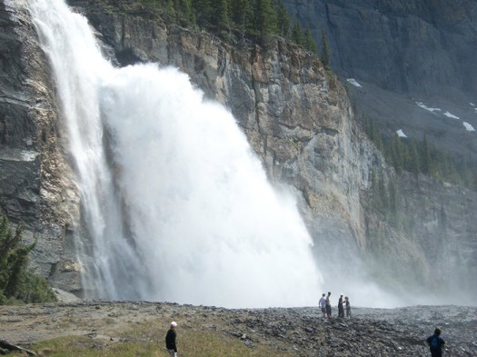
It’s positively dangerous. Get as wet as you want.
A good contest for your group is to see who can get closest to the force of the Falls.
I posted a number of Emperor Falls photos on flickr from our 2003 hike.
exploring the world by internet

ANTONAMON from the Netherlands loves to photograph mountains and rivers, rocks and sea. He says at 73 he is now too old for hiking trips but he browses the internet to see what’s out in the world.
“I stay at the coast and try to picture the eternal struggle between rocks
and waves.”
web search: Google, Live, Yahoo
Hoo hoo!
First time ever besthike.com has reached #1 on any of the 3 major search engines.
Microsoft Live ranks us #1 for the search term “best hikes”. Google #9 and Yahoo #2.

Our list of the best hikes in the world is the best we know of on the web. It’s nice to know people can find us.
