KAMADAC is a German – Venezuelan run travel agency based out of nearby Santa Elena.
Their guides speak Spanish, German and English.
How can you resist?
The prices are really good value. Click through to see for yourself – kamadac.de


Best hikes, treks, tramps in the world.
KAMADAC is a German – Venezuelan run travel agency based out of nearby Santa Elena.
Their guides speak Spanish, German and English.
How can you resist?
The prices are really good value. Click through to see for yourself – kamadac.de
#Jeju #JejuOlle
trip report by site editor Rick McCharles
Day 4 had been long long, over 30km. In the dark I lucked into finding a perfect tent site, hidden away in a rock niche high above the coast.

It had previously been used as a meditation retreat.

Dawn is the most peaceful time of the day. They are not early risers on Jeju.

Locals live by the “Sam Mu” (“Three Nothings”) – no beggars, no thieves, no gates.

Here is (by far) my favourite restaurant over 100km – the Two Weeks Coffee Shop.

The owner retired from Seoul. Because he and his wife love coffee, they purchased the property to set up a retirement job.

Every Korean can guess why it’s named Two Weeks. … You’ll have to go yourself and ask if you want to know. Bring a book and a laptop. They have free WiFi. You can hang out in their lovely garden.

Check the vista from atop the nearby cinder cone.

Known as an “oreum” (lateral volcano grown over as a hill or small mountain), the Jeju Olle never bypasses one without making you climb to the top.

That’s the second largest “city” on Jeju, Seogwipo.

They have the same huge, colourful web spiders I’ve bumped into many times in Hong Kong.

I imagine these small, timid feral cats eat the spiders, when they can.

I finished at the official Jeju Olle office in Seogwipo, a bit disappointed that I ran out of time to do route 7. Some feel that’s the best of all.
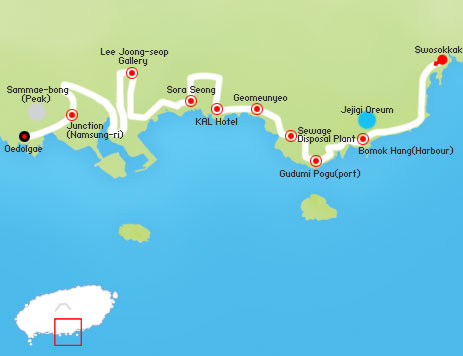
Read more about route 6 on the official website.
See the rest of my route 5-6 photos on flickr.
_____
Resources if you want to plan a trip for yourself:
Visit Korea – Jeju Olle (also available in many other languages)
JejuOlle.org (also in Japanese, Chinese and Korean)
Wild Junket – Hiking in Korea: Jeju Olle Trail
Though I did not use it, there is a guidebook in English. Look for it on the island or check it out as a PDF linked from this Visit Korea page.
Questions? Suggestions? … Leave a comment.
Marco Nef from Switzerland alerted me to their excellent and unique website on the famed 220mi traverse.
Each page of the trip report is synchronously bilingual: German and English.
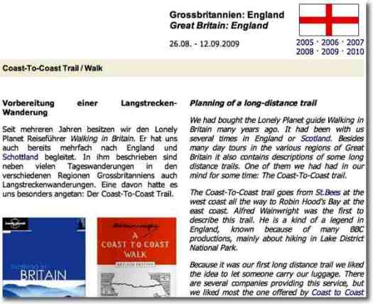
The Coast-To-Coast trail goes from St.Bees at the west coast all the way to Robin Hood’s Bay at the east coast. …
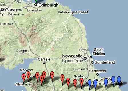
check it out at coast-to-coast.ch
It’s also known as the Coast to Coast Walk.
#Jeju #JejuOlle
trip report by site editor Rick McCharles
Day 1 | 2 | 3 | 4 | 5 | (routes 1→ 6 = 106km)
This page recounts routes 4 and 5.
An early start again, the Festival tents were not yet open. So I missed a couple of passport stamps.
One town had entertainment for those of us in the Walking Festival. For example, here is a traditional drummer.

Everywhere you turn on Jeju island you’ll see reminders that this is a nation prepared for war. Most military installations are unmanned, but covered in camouflage.

On the trail the military has posted photos, including this one.

We visitors were all charmed by the local dogs of the island. Very mild mannered, they rarely even bark. It seemed perhaps 70% of the pet dogs were of this one breed.

Slippery sections of the Jeju Olle are improved with these recycled tire mats.

The foreign experts were not impressed. What happens when they (inevitably) break up?

An inland section routes past an impressive Buddhist monastery.

I didn’t take the time to visit. But it seemed to be welcoming to hikers.

The biggest crop at this time of the year is Mandarins.

But many others were being taken off the fields. Several different grains were drying.

I was a little surprised how undeveloped the coastline is … for an island so based on the fishery.

Linda Myers estimates 30,000 walked one of the Jeju Olle pathways in 2008. And 150,000 in 2009. That will have grown again in 2010, yet it never feels crowded.


Read more about route 4 on the official website.

Read more about route 5 on the official website.
See the rest of my route 4 & 5 photos on flickr.
#Jeju #JejuOlle
trip report by site editor Rick McCharles
Day 1 | 2 | 3 | 4 | 5 | (routes 1→ 6 = 106km)
I did part of this route with the Walking Festival. And came back later by myself, to finish.

Walking in Korea and most of Asia is traditionally for the purpose of religious pilgrimage. To walk for fun and fitness is a relatively new and foreign concept.
Festival motto – be happy on the trail

Perhaps the most amazing sight on the sections I hiked was this vast area covered with Mandarin orange peels. We were told that, once dried, it would be used in tea.

The aroma was wonderful.
It was here, too, that our hiking group sampled the famous Jeju pork. Delicious.

Of the stretches along the water, I think this was my favourite.
Near the coast there are always surf cast fishermen in sight.

Most of the “beaches” are black and stony …
This one, Pyoseon, near our official Conference hotel was a rare sandy treat

We took a shortcut to the finish

Christian funeral monument.

Korea is about 40% Christian though none of the huge churches you’ve seen on TV are located on Jeju.

One of the bloggers saw some of the famous diving women of the island close to here.
It’s an interesting story, those divers.
Another saying of this island is that “rocks, wind and women are plentiful“. It’s a bit of a matriarchal society.
Haenyo are skilled divers who are known to be able to hold their breath for more than two minutes and dive to depths of 20 meters. Diving was the first profession for women in Korea and the Haenyo are some of the best free divers in the world.

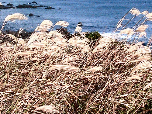
I set up a tent in a spot hidden by tall grasses. This, my only companion, didn’t reveal I was there.

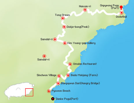
Read more about route 3 on the official website.
See the rest of my route 3 photos on flickr.
#Jeju #JejuOlle
trip report by site editor Rick McCharles
Day 1 | 2 | 3 | 4 | 5 | (routes 1→ 6 = 106km)
I did this section solo, starting very early morning. There wasn’t much of a sunrise over Sunrise Peak.

We’ve categorized this a coastal trail as it more often than not stays near the shoreline, moving inland to visit highlights.

Most walk in the normal direction, colour coded Blue. But if you wanted to meet more people, there’s no reason not to walk it backwards, following the Orange signage.

The world “Olle” comes from an old local dialect of Korean. It can be translated as “a very narrow path from house to the closest road”.
The philosophy of the trail builders was to find existing, sometimes disused, pathways less than 1m wide. And to rejuvenate them.
That’s the ideal. In reality, the need to keep the route close to buses and toilets results in paved surfaces perhaps 70% of the route. My feet were bruised and sore after 100km.

Still, there’s rarely much traffic. Jeju island is ideal for road biking though that’s not yet caught on. i did see perhaps a couple dozen recreational mountain bikers over the week I was there.
There’s no official policy regarding cycling the Jeju Olle. But organizers will try to discourage it. (They can’t ban bikes as most of the trail is on public roadways.)

Shout out to the many volunteers at the Walking Festival. It was a great pleasure to arrive at each tent to get my passport stamped, get water, and recharge my enthusiasm.
Traditional stone figures are common on Jeju. … Next time I’m going to learn the significance of each.

They are proud of their beautiful turnips on Jeju.


I didn’t research insects. One morning in wet grass I did see mosquitos. They did not pester.

If you can live on “Mandarin oranges“, you need not carry any food in November. It’s harvest time. Every farmer wants you to try some of his.

One of the more lovely sections this day …


Read more about route 2 on the official website.
See the rest of my route 2 photos on flickr.
The Way Back is an upcoming drama film about a group of prisoners who escaped from a Siberian gulag during World War II.
… directed by Peter Weir from a screenplay also by Weir based on the memoir by Sławomir Rawicz. It stars Jim Sturgess, Colin Farrell, Ed Harris …
The film is based on a memoir titled The Long Walk by Slawomir Rawicz, depicting his escape from a Siberian gulag and subsequent 4000 mile walk to freedom in India. Incredibly popular, it sold over 500,000 copies and is credited with inspiring many explorers.
In 2006 the BBC unearthed records (including some written by Rawicz himself) that showed he had been released by the USSR in 1942 and the book was based on the story of other Polish soldier, Witold Glinski. …
Click PLAY or watch the trailer on YouTube.
They are already talking Oscar nominations.
(via The Outside Blog posting on three men who repeated the walk to raise awareness that the real hero real hero of the Great Escape was a Polish man named Witold Gliński.)
#Jeju #JejuOlle
As I post, tensions are high between North and South Korea after the artillery exchange of November 2010 – the Shelling of Yeonpyeong. I wish peace for all in both nations.
_____
trip report by site editor Rick McCharles
Day 1 | 2 | 3 | 4 | 5 | (routes 1→ 6 = 106km)
Depart from the beautiful ‘Siheung Elementary School’ and climb up Malmi Oreum and Al Oreum. At the top of the volcanoes you’ll see Seongsan Ilchulbong (Sunrise peak), along with Woo-do (Island) and many picturesque farms will catch your eye. The route continues along the salt fields in Jongdal-ri to the esplanade in Siheung-ri.
When walkers reach Sumapo Beach, the Seongsan Ilchulbong (Sunrise peak) appears once again. The color of the sea at Gwangchigi Beach (the terminus of Route 1) is truly unforgettable.
We started at the beginning, Siheung Elementary.

The weather threatened, but turned out to be good walking. Windy and cool.
A group of us from the Walking Festival unloading from the bus to begin.

These volcanic stone walls are emblematic of this island.

In the Cotswolds, UK, stone wall masons study for 3yrs. Likely fitting these together takes more skill than it appears.
Jeju Olle is very well signed. Ribbons flag the route, as well as other devices.

This was my first good view of Sunrise Peak (Seongsan Ilchulbong), the geological highlight of my hike.

You could see how volcanic soil and a mild, wet climate make Jeju ideal for agriculture.

Our first of the famed Jeju ponies.

They are one of the symbols of the Jeju Trail.

As part of the Walking Festival, we enjoyed many treats and surprises en route. A piano, at one point. Singers at many other highlight sections of the trail.

The professor is also an opera singer. Our charismatic leader, Suh Myung-sook, convinced him to sing, as well.

For the two days prior, at the conference, I had heard many apologies regarding too few toilets on the Jeju Olle. Much to my surprise the toilets were excellent.

Signs marked the distances between, rarely more than 4km apart. (Many are squatters, however. And some are signed only in Korean.)
We foreigners had much discussion about the many burial plots.

Tradition is that bodies are cremated. Then buried in sometimes spacious stone rings. … It seemed to us (from outside the culture) that much arable land is lost to the farmer.
More treats for the walkers. Fresh carrot juice. And some kind of tasty sweet.


Finally, Sunrise Peak. The highlight is a short, steep climb to the summit. (That’s not actually part of the official hike, so I came back another day to join the throngs climbing it.)

Read more about route 1 on the official website.

See the rest of my route 1 photos on flickr.
Ace and Patricia hiked the most southerly established major trail in South America, part of the Circuito Dientes de Navarino.
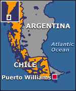 I read their trip report with interest. I’d once traveled to Punta Arenas intending to do Dientes, but ran out of time to arrange the tricky transportation to the Puerto William, Chile, on Isla Navarino. That’s the jumping off point for Dientes.
Ace and Patricia ended up taking the Zenit’s 15 passenger boat from Ushuaia, Argentina, to Puerto Williams. And later found a flight back on a 3-seater plane.
Extreme weather in this most extreme part of the world makes all manner of transportation a gamble.
Was it worth it for Patricia?
Yes.
… We reached the dip between the peaks and were rewarded with breathtaking views of the spiky Dientes and across Isla Navarino to sets of islands beyond. It was a clear day and we saw the islands of Cape Horn. It was definitely the highlight of the trip. …
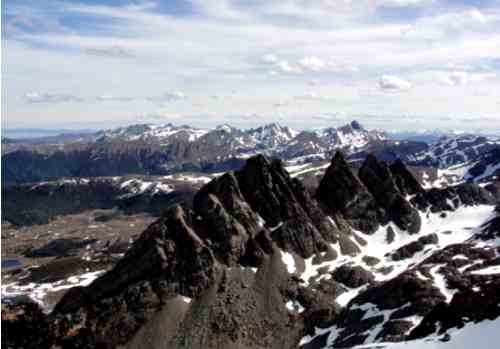
Painted stones & cairns mark the trail. Unfortunately many of those were covered by snow.
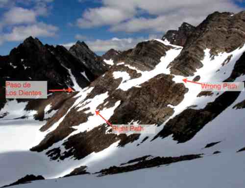
Everyone has navigation challenges on Dientes, this adventure more than most. Their goal on day 2 was to cross Paso de los Dientes. The guidebook said to “stay high”. … They stayed too high, eventually having to backtrack when the risk of a mini-avalanche got too great.
If you’ve ever dreamed of hiking the teeth of south South America, download Patricia’s Trip Journal. (PDF)
Check our Dientes information page.
More rugged and remote than the Himalayas.
The Asgard Project – OFFICIAL Climbing Teaser – Posing Productions
Click PLAY or watch the trailer on YouTube.
… objective to make the first free ascent of the west face of Mt Asgard on Baffin Island. Like that’s not an awesome enough feat in itself the journey there will be pretty special involving training trips to Riglos in Spain, Brento in Italy and Yosemite in California! …
The film crew hiked in to this location in 5 days.
(via The Adventure Channel)

