walking Safari – Zambia

Mosi-oa-Tunya National Park is an UNESCO World Heritage site that is home to one half of the Mosi-oa-Tunya — ‘The Smoke Which Thunders‘ — known worldwide as Victoria Falls on the Zambezi River.

The river forms the border between Zambia and Zimbabwe, so the falls are shared by the two countries, and the park is ‘twin’ to the Victoria Falls National Park on the Zimbabwean side. …

The wildlife section of the park is tiny but popular. Popular because half day walking safaris are offered.

This is rare in Africa due to the risk of tourists being injured. Or eaten.

It was very early. Very rainy when I was picked up — alone — at my hostel.

P1270709

We rendezvoused with a British couple alongside the Zambezi.

Everything was about to go wrong. You had to laugh.

P1270710

P1270719

The husband had 2 new hips, 1 new knee. He could not walk.

Improvising, we decided to take a quick driving safari before setting out on the promised “walk”.

P1270735

P1270721

African guides are normally super entertaining. Very knowledgeable.

We saw baboon, vervet monkey, giraffe, zebra, warthog, sable, impala and many other antelope.

P1270767

P1270756

P1270745

P1270731

When the British couple departed, I was alone for the walking Safari with a support team of up to 4 men.

I walked with a guide and an armed guard.

P1270785

There’s no shortage of wildlife in Mosi-oa-Tunya National Park. But the main attraction is white Rhino. Though not indigenous, they are the most talked about wildlife in Africa.

You cannot see rhino from the road. They are understandably very shy.

Already an hour or more late, we roamed far and wide in the wet mud looking for rhino sign. The guard checked his phone constantly for an update on where we might find them.

Finally, the highlight of Mosi-oa-Tunya. A mother Rhino and her new baby, less than 2 weeks old.

IMG_1885

IMG_1892

The rhino in Mosi-oa-Tunya were poached to extinction in 2007. 😦

I was told they are no longer worried about poaching here. The Park is now fiercely defended. 5 adult rhino and 5 youngsters, including this newborn.

On the other hand, the enforcement officer spoke longingly of Botswana where guards can (reportedly) shoot poachers on sight.

more of my photos from the day

Victoria Falls, Zambia

While it is neither the highest nor the widest waterfall in the world, it is classified as the largest, based on its width of 1,708 metres (5,604 ft) and height of 108 metres (354 ft), resulting in the world’s largest sheet of falling water.

… In height and width Victoria Falls is rivalled only by Argentina and Brazil’s Iguazu Falls. …

The spray from the falls typically rises to a height of over 400 metres (1,300 ft), and sometimes even twice as high, and is visible from up to 48 km (30 mi) away. …

Though a jerk and inept leader, David Livingstone was one of the first Westerners to make a transcontinental journey across Africa. And might have been the first non-African to see Victoria Falls.

statue near the Falls

Although Livingstone is known as “Africa’s greatest missionary,” he is only recorded as having converted one African. That might be to his credit, actually. 🙂

New York Herald reporter Henry Stanley could not convince Livingstone to leave. The great explorer died of malaria and dysentery.

IMG_1856

The baboons look bored. But I was thrilled to finally reach Victoria Falls, one of the great tourist destinations of the world.

From the Zambia side, you get an unbelievable distant photo vantage.

IMG_1826

First Gorge, from Zambian side

IMG_1824

Walking the Knife-Edge Bridge during high water is something like walking through the waterfall. It’s not always easy to see the Falls.

IMG_1847

Drenched anyway, I made the wet descent to the river on the Boiling Pot trail.

IMG_1863

IMG_1862

That day I didn’t see anyone bungie jumping from the Victoria Falls bridge. But I hear it’s awesome. (VIDEO)

My photos don’t do this natural wonder of the world justice. Nobody leaves disappointed. Victoria Falls are magical.

Click PLAY or watch a video on YouTube.

I’d love to return, just to visit from the Zimbabwe side.

IMG_1816

Paine Circuit, Chile

Mike Howarth posted another of his terrific adventure photo journals, this time the famed Paine Circuit in Patagonia.

… Away from the majesty and spectacle of the W circuit, the southern half of the Paine Massif offers something completely different, a peaceful beauty. As the trails widen and birds chatter I remember why I am here. …

Paine

We stumble over the Paso John Gardiner like two drunkards buffeted by the wind. Laughing and whooping at the ferocity.

Glacier Grey

Afforded amazing views down to Glacier Grey and the Southern Patagonian Ice Field stretching off in to the distance.

Justin

read the trip report – Torres Del Paine – The Full Circuit

Trail Therapy – Steve Fugate

The Journey Continues

Backpacker TV:

In 1999, Steve Fugate lost his son to suicide. A few years later, he lost his daughter to a drug overdose.

At sixty-four years old, he has walked across the United States seven times to raise awareness for depression and suicide and to inspire people he meets to “love life.” After fourteen years and 34,000 miles of walking, Steve continues his quest to heal his heart and the hearts of those in need one step at a time. …

Click PLAY or watch it on Vimeo.

Earl—the Rugged, Revolutionary Tablet

Leave the iPad at home.

Outside:

This new backcountry survival Android tablet works where your smartphone or iPad would fail. The rugged tablet can forecast the weather, determine your location, elevation, and let you communicate with folks back home.

About the size of an iPad mini, Earl is one tough gadget. It’s waterproof, dustproof, shockproof, and it will work in temperatures from 32 degrees to 122 degrees Fahrenheit. You can submerge it in three feet of water for up to 30 minutes with no ill effects.

Earl’s GPS uses an internal magnetometer, accelerometer, and gyroscope to track your position. It’ll guide you even if you’re navigating dense vegetation or an urban jungle without a line of site. It also gives you access to more than 300,000 trails through the site everytrail.com and high-resolution topographical maps of North America. With Earl in your hand, you have no excuse to get (unintentionally) lost. …

earl-survival-tablet_fe

Outside

Community Inca Trail Trek

guest post by Helene Cooper:

Last month I embarked on one of the most amazing experiences of my life, Peru’s Inca Trail. I took part in a five day “Community Trek”, which goes a little more off the beaten track, combining an exhilarating trek along the Peruvian Andes, with an opportunity to camp with local villagers and help with farming and community work.

En-route I enjoyed some of the most beautiful mountainous terrain I’ve ever seen, stopping at amazing ancient ruins and pushing my body to new extremes. The Community Trek gives you the opportunity to give something back to the local people, with a proportion of your fees helping with their schooling and farming activities. While you see less of the ruins than on the Classic Trek, you still see the best, while enjoying a completely different experience, too.

The trek was amazingly hard work, with high altitudes making the long hikes exhausting at times, but with the end reward of Machu Picchu just hours away, it was well worth it. The trails are less preserved than on the Classic Trek, which makes it harder work, but what’s life without a little challenge? The opportunity to spend time in local communities gave the trip an added attraction; I really recommend you try it.

Day 0:

We begin our five-day journey with a pre-trek meeting with our guides from Andina Travel. Everyone takes the opportunity to ask any questions and psyche themselves up for the next four days of walking. We’re told to prepare for the high altitudes, which can reach up to 13,900ft.

Day 1:

We’re picked up early by a minibus; it’s a beautiful clear day and the mountains are simply awe-inspiring – I can’t wait to crack on with the trek.

First stop is Saksaywaman, an incredible old ancient fortress overlooking Cusco; giant boulders are stacked as if they fell from the sky – it’s a great photo opportunity! Our guide tells us this was once a historic, religious and ceremonial place, which you certainly get a feel for.

Next we move to the Sacred Valley, a huge gorge between two steep mountains and home to hundreds of maize fields and numerous tributaries, what an amazing sight!

We trek on to the Pisac ruins and its fantastic terraces and walkways, where we get to put our feet up and give our lungs a rest. We purchase walking sticks, coca leaves and colourful plastic ponchos, the last supplies for our mammoth trek.

After lunch it’s time to start walking! We tentatively start climbing our way up the hills and slowly the scenery starts to change. The higher we climb the colder it gets, and the air starts to thin out, which is a strange feeling.

Our tents are already set up when we arrive to our first camp in the amazing Andes. We’re greeted by hot popcorn and cold drinks in the kitchen tent – very civilised! A pack of cards come out and we play and talk about today’s sights until dinner is served.

I’m starving and it was a pleasure to be served a delicious three course meal including ‘Cuy’, roasted Guinea Pig on a spit, which is really succulent and tasty, followed by a hot cup of Peruvian tea to warm us up, as its now getting pretty cold – I put socks on my hands to keep warm.

Day 2:

The morning starts with a soft knock on our tent and the voice of our guide calling: “coca tea!”

We poke our sleepy heads out to find mugs of steaming tea and a hot basin of washing water waiting for us. What luxury! The coca tea is a greenish yellow colour and has a mild bitter flavour, similar to green tea, but gives you a wake-up kick like a good cup of coffee.

Our cooks continue to spoil us with a breakfast of porridge, toast and eggs, which feels like a real treat. We pick up our snack bags, which include some local fruit and biscuits, and set off for a full day’s walking. Small steps and deep breaths is definitely the recipe for success.

En-route we meet some little old ladies running up the mountain paths without shoes, carrying heavy loads on their backs. Kids hike their way to school down the valley and we all feel a bit sheepish in our Gore-Tex hiking gear.

I feel a real respect for the people living in these harsh conditions, it’s bitterly cold and arid in places, but absolutely stunning nonetheless. We advance towards the highest point of the trek, which is surrounded by clouds and looks incredible.

The air is so thin it’s really hard to fill your lungs with oxygen and my body is getting really tired. As we reach the summit we reward ourselves with a shot of Pisco, which is quite the livener; each of us pouring a drop on the ground as a sacrifice to Pachamama (Mother Earth).

Finally we venture downhill and race towards our lunch stop. The porters and cooks overtook us a long time ago and have served up some delicious hot food, including local rice and beans.

Day 3:

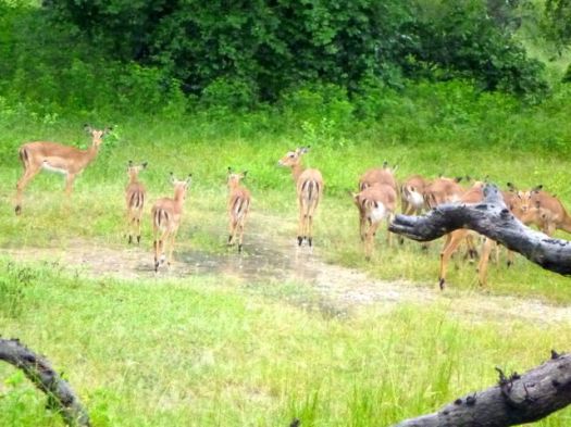
More trekking, I can feel myself getting fitter as we progress, but it’s still a strain on the limbs. There are herds of alpacas and llamas on the mountain sides, which I feed with some of my biscuits; the llama is like a cross between a camel and a sheep and laps up my snacks.

We conquer another high pass and stop for a few photos of the stunning green mountain lakes on show, which shimmer in the sunlight, it’s great to be alive!

We cruise downhill for lunch at our second campsite. I have an afternoon nap while some of the guys play football. At night the stars are shining and we admire the silent stillness of the Andes; it feels like we’re the only ones in the world that are enjoying this moment.

Day 4:

We visit a local school where we work with the local children, helping with break activities, singing and poetry lessons, it’s really good fun. None of the children can speak English but they enjoy learning some useful phrases, like llama and Guinea pig!

We get Quechua lessons, the local dialect, from a teacher, who teaches me “sulpayki wayki” (thank you friend)! We then move on to a local farm and help them with planting and weeding and I buy a nice colourful hat from a local weaver.

Our last day of trekking is short and fortunately it’s all downhill, unsurprisingly nobody complains! We’re sad to say goodbye to our team of porters and cooks as we hop on a bus to Ollantaytambo.

On arrival at our lodge in Ollantaytambo we have glorious hot showers and a short rest before a guided tour of the Ollantaytambo ruins, the royal estate of Emperor Pachacuti. The town is home to a large settlement, so we have dinner in a local restaurant which serves some delicious soups and stews with ‘pan de papa’, a bread made with mashed potatoes.

No sooner have we finished eating we are eager to get back to the lodge to try out those lovely looking beds, which do their job very well indeed.

Day 5:

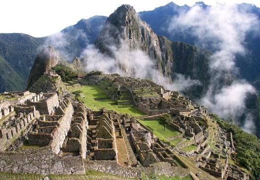
Today we embark on the final part of our journey, towards the epic Machu Picchu; I am so excited! We have an early breakfast and jump on the train to Aguas Calientes, which has some really picturesque views on route. Unfortunately we don’t arrive at Machu Picchu until late morning, so miss the sunrise, but we still arrive earlier than the masses of tourists, which I’m pleased about.

We take a shuttle bus to Machu Picchu, which suddenly appears on the horizon, lying on a steep sunlit mountain side. We meet up with the other trekkers, who took the more traditional, “Classic” Inca Trail route; they are yet to shower and are pretty envious of our fresh smells!

We have a couple of hours of free time to look around the Machu Picchu complex, so we hike up to the Sun Gate, which offers an amazing view on what is a beautifully clear day; the others take the opportunity to have a closer look around the city’s ruins.

Machu Picchu

Soon it’s time to head back; we board the bus and train to Ollantaytambo and our transfer takes us to back to Cusco, where we tell stories about our experiences of the last five days.

We all have aching muscles, blisters and the odd tummy ache, but the amazing scenery and ancient ruins were well worth it. I can’t recommend the Inca Trail highly enough.

Helene Cooper currently writes for Dragoman, the overland adventure operator

related – our Best Hikes South America list

Gxalingenwa hike, South Africa

trip report by site editor Rick McCharles

One of the best day hikes in South Africa.

At Sani Lodge Backpackers in the Drakensberg you get everything you need.

trail description, permit, map

Step out the back door, you’re on your way.

IMG_0209

IMG_0212

After about 250m you reach the perimeter fence of the KZN protected lands. Permit to hike costs about $3.

IMG_0214

Every step is beautiful in the Drakensberg. Wide open.

IMG_0217

Some African dung beetles are endangered. NOT the ones in these mountains. There are plenty.

IMG_0224

Lizards are constant companions.

IMG_0229

You see a lot of scat, many interesting prints, yet not much wildlife. Animals here have evolved to be elusive.

IMG_0235

I was thrilled to see my first grey rhebok.

IMG_0232

Alpha males “cough” at you from a safe distance.

Wild flowers were still in profusion, mid-summer. We’d had a lot of rain.

IMG_0245

I left a Summit Stone for some future hiker to discover.

IMG_0220

Here’s Gxalingenwa cave. These two spent two nights here, sheltered from the rain.

IMG_0249

Later I learned you are not officially allowed to camp there.

From the cave I had to either backtrack … or finish a loop down the river.

IMG_0252

I’d been warned that the water was high. That I’d most likely need to wade the creek several times.

IMG_0255

Boulder hopping my second crossing, I fell in. 😦

And — since the shoes were wet — I waded 3 more crossings.

IMG_0253

IMG_0256

Russell at Sani Backpackers wants to improve the trail staying on one side of the creek. One day.

IMG_0260

I was glad to have done Gxalingenwa as a loop. It’s very pretty coming down.

IMG_0258

IMG_0259

Some hike up to these waterfalls from the roadway.

The only downside of the Gxalingenwa loop from Sani Backpackers is a road walk finish.

IMG_0265

Happily, I was picked up. Given a lift by University researchers who happened to be staying at the Backpackers.

more photos from this day hike

Lake of Eternal Life, Iceland

HANK LEUKART:

Brian and I start by trekking two classic, connected Iceland treks: the Fimmvörðuháls and Laugavegur Trails, the first of which begins at a huge waterfall called Skógafoss on the southern coast.

We feel almost disappointed to be enveloped by the sublime, rolling, green hills and plethora of waterfalls, because it feels like we’re in the most beautiful place in Iceland already — we’re getting a fantastic payoff way too early in our trip. Soon enough, though, as we continue through the snow and glaciers near Fimmvörðuháls Hut, it becomes obvious that there’s no chance Iceland will ever disappoint us no matter where we go. …

Click PLAY or watch it on Vimeo.

In January 2014, the Icelandic government announced plans to revoke 30-year-old environmental protections, putting Mývatn Lake, the Þjórsá River, and the Highlands in danger of destruction so that new hydropower plants can be built. Three waterfalls on the Þjórsá River — Kjálkaversfoss, Dynkur, and Gljúfurleitarfoss — may be ruined. Now may be the last time in history that hikers can see all of Iceland’s natural, untouched beauty …

read more – Without Baggage – Mission Iceland: A Tale of Two Brothers

Two brothers search for eternal life in the Icelandic wilderness.

Kili’s Machame-Mweka route

Bob Foulkes:

I signed up, raised some money from incredulous friends, some of whom thought it cheaper to give than to have me committed, and started training.

On January 13, 2014, in my 65th year, I joined the group in Amsterdam for the flight to Moshie to start the trek to summit Mount Kilimanjaro. We are 13, 10 women and 3 men, ages varying from mid twenties to mid sixties. We’ve raised almost $100,000 for Outward Bound and have paid our own way here.

Summiting Kilimanjaro is simple but not easy. …

At 5895 meters (19, 340 feet), it is Africa’s tallest peak. It demands a high level of fitness; six to eight hour days of high altitude trekking is demanding. Our well trodden trail, the longer Machame-Mweka route covers 55 kilometers that takes us up a flank of the summit and then traverses slowly across the width of the mountain to the final camp above 4800 meters; from which we strike out for the summit. The longer route allows more time for acclimatization, improving our chances of summiting. …

read more – Climbing to the top of Africa – Part 1

Kili

Bob’s book will be available soon — Off the Couch and Out the Door.