Listen up trekkers, backpackers, and thru-hikers, Backpacker magazine has a new tool that you might be interested in, particularly if you plan on walking the Appalachian Trail.
The recently launched 3D map of the entire route of this iconic trail puts a host of great information at our fingertips, giving us new ways to explore this amazing path without ever leaving home.
The 3D map, which can be found here, covers the entire 2190 mile (3524 km) length of the AT. …
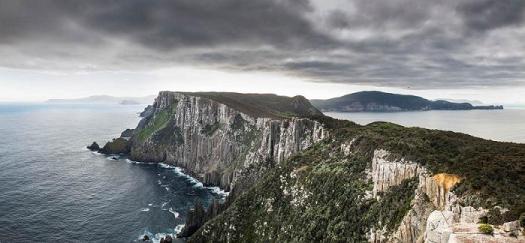
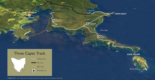
Has the Overland Track, Australia’s most famous long-distance walk, just been usurped? Edging along the tops of cliffs that soar more than 300m above the unruly Southern Ocean, the Three Capes Track (threecapestrack.com.au) has quickly assumed the mantle of Australia’s most intriguing bushwalk.
The four-day, 46km track opened to huge expectations at the end of 2015 …
… criticisms that have hounded the track are the cost (at AU$495 per person, it’s more than double the price of the Overland Track) and initially there were no camping facilities for traditional bushwalkers. …
To regulate walker numbers, which have been capped at 48 setting out each day, Tasmania’s Parks and Wildlife Service has established a permit system. Bookings should be made at threecapestrack.com.au/booking.
The walk officially begins at the Port Arthur Historic Site, about a 90-minute drive from the Tasmanian capital of Hobart.
I’m planning on the Chinese Wall in Bob Marshall Wilderness, Montana myself. June 2020.
Start about 85 miles west of Great Falls, at the South Fork Sun River Trailhead, and hike 23 miles northwest. You’ll climb along the Continental Divide and spot elks, moose, and mountain goats along the way. Once you reach White River Pass, at the southern end of the wall, you’ll find a choice of multiple routes, including an eight-mile trail along the wall that ends at a lookout called Larch Hill Pass.
You might be able to find it on the National Geographic Channel.
In 2016 filmmaker/photographer Pete McBride and writer Kevin Fedarko set out on a 750-mile journey on foot through the entire length of the Grand Canyon.
From the outset, the challenge was far more than they bargained for. More people have stood on the moon than have completed a continuous through hike of the Canyon.
… But their quest was more than just an endurance test – it was also a way to draw attention to the unprecedented threats facing one of our most revered landscapes. …
Uranium mines, tourist development, maintaining indigenous flora and fauna. Native peoples are interviewed thoughout.
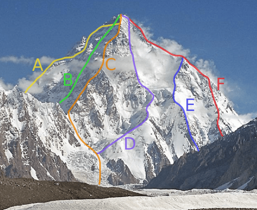
In advance of a trek to K2 Base Camp and Gondogoro Pass, I’m doing some reading about those insane alpinists that dare to climb the second highest peak in the world.
The Dragon’s Back is more than a hike, it’s a “tourist attraction”.
The Dragon’s Back (Traditional Chinese: 龍脊) is a ridge in southeastern Hong Kong Island, Hong Kong, between Wan Cham Shan and Shek O Peak. It lies within the Shek O Country Park. In 2004 the Dragon’s Back Trail was selected by TIMEasia as the best urban hiking trail.
Who wouldn’t love a ridge walk on a tropical island?
Many start up the Hong Kong tram and hike down to Big Wave Bay, but I followed the longer and more difficult 8.5km route recommended in The Inside Guide to Hikes and Walks in Hong Kong, a free publication from Hong Kong Tourism.
If you get to Hong Kong, the Dragon’s Back is a must hike.
Friends, loved ones and unloved who don’t want to go can wait at the finish, Big Wave Bay Beach.