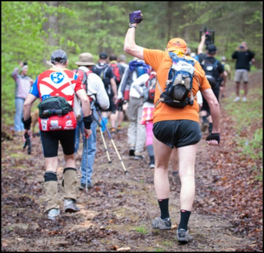
WHAT!?
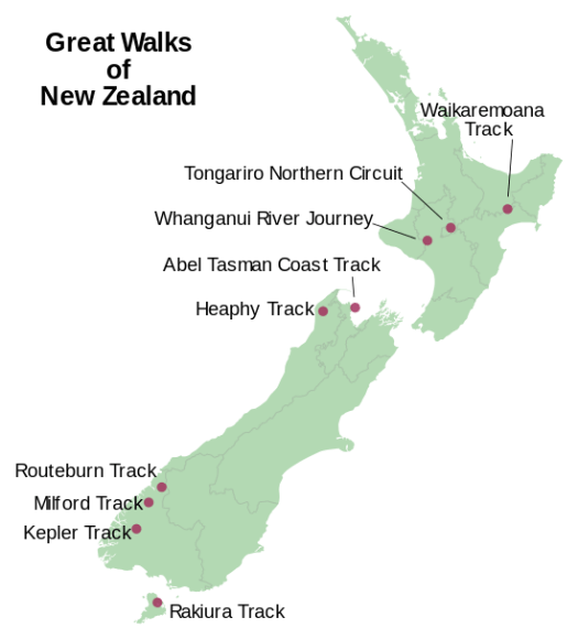
One is a river paddle, the Whanganui Journey, 145 kilometres (90 mi).
Is this even possible?
Click through to see if these guys made it — AND THEN THERE WERE NINE

Best hikes, treks, tramps in the world.
WHAT!?
One is a river paddle, the Whanganui Journey, 145 kilometres (90 mi).
Is this even possible?
Click through to see if these guys made it — AND THEN THERE WERE NINE
Yeesh. North Face ultra-runners Mike Foote and Mike Wolfe.
Especially for trail running. 🙂
See more.
… In the nearly 30 years since the Barkley’s inception, only 14 people have finished the race. …
Outside – How Two Filmmakers Cracked the World’s Most Bizarre Trail Race
The Barkley Marathons is a 100 miles (160 km) run and a 60 miles (97 km) ‘fun run’ held annually in Frozen Head State Park near Wartburg, Tennessee in late March or early April.
The course itself, which has changed distance, route, and elevation many times since its inaugural run in 1986, currently consists of a 20-mile (32 km) loop with no aid stations except water at two points along the route and the runner’s parked car at the beginning of the loop. Runners of the 100 Mile version run this loop five times, with loops three and four being run in the opposite direction and loop five being runner’s choice. …
Click PLAY or watch the trailer on YouTube.
Kilian Jornet Burgada is the most dominating endurance athlete of his generation. …
… He has run across entire landmasses (Corsica) and mountain ranges (the Pyrenees), nearly without pause. He regularly runs all day eating only wild berries and drinking only from streams. …
A few years ago Jornet ran the 165-mile Tahoe Rim Trail and stopped just twice to sleep on the ground for a total of about 90 minutes. In the middle of the night he took a wrong turn, which added perhaps six miles to his run. He still finished in 38 hours 32 minutes, beating the record of Tim Twietmeyer, a legend in the world of ultrarunning, by more than seven hours. When he reached the finish line, he looked as if he’d just won the local turkey trot. …
So what’s next when you’re 25 and every one of the races on the wish list you drew up as a youngster has been won and crossed out? You dream up a new challenge. Last year Jornet began what he calls the Summits of My Life project, a four-year effort to set speed records climbing and descending some of the world’s most well known peaks, from the Matterhorn this summer to Mount Everest in 2015. …
On a trail run/hike out of my residence, Whistler’s Athletes Lodge, I passed this pretty volcanic crater lake.
You can’t lose hiking near Whistler B.C.
It’s all good.
One of the easier Whistler, BC, Canada lakes to access by walking a short distance. But, be aware, the distance to the lake may be short but the steep climb to the lake is not easy. … mainly loose rocks following a deactivated road, now hiking and mountain biking trail, for 350 metres.
Loggers Lake – Whistler, BC, CanadaLogger’s Lake, considered a watershed, is a small lake surrounded by trees and rock formations located in the Whistler Interpretive Forest. …
trip report by site editor Rick McCharles
Though I’d rushed through Snoqualmie Pass dozens of times over the years – to or from Seattle – this was the first time I’d ever stopped to hike.

4.0 miles, roundtrip
Gain: 1160ft
Highest Point: 2078ftNo pass or permit required. And, no, there are no rattlesnakes.
This is a fine hike on a well maintained, albeit busy trail through the forest with views of the Cedar River watershed, Mount Si, Mount Washington, Rattlesnake Lake and Chester Morse Lake.
As soon as you arrive in the parking lot you have a view of Rattlesnake Ledge’s sheer rock face across Rattlesnake Lake. At this point it seems amazing to think you will be up there by the end of your hike, but a look at a trail map will reveal some well-engineered switchbacks …
WTA – Rattlesnake Ledge
It’s super popular. Hikers. Dog walkers. I saw many trail runners. (I walked up. Ran down, myself.)

Careful. In 2009 two different hikers fell to their deaths.


related – A lookout of legendary proportions
A 23-year-old Seattle man has smashed the speed record for hiking the full length of the Pacific Crest Trail. Recent college grad Joe McConaughy crossed into Canada on Sunday, exactly 53 days, 6 hours and 37 minutes after leaving the Mexican border on the storied trail. McConaughy says he felt elation and disbelief at the finish of the 2,660 mile journey. …
There is no official time keeper for long distance trail records. McConaughy had a support team and a satellite tracking beacon to verify his time. He says he ran the downhill and flat sections and generally hiked the uphills.
Even McConaughy sounds astonished by the pace he maintained. “I can’t believe that I averaged 50 whole miles a day over some of the toughest mountains in the West …
Seattle Runner Smashes Speed Record For Full Length Of Pacific Crest Trail
Click PLAY or watch an interview en route, near Bend, Oregon.
The long distance hiking fraternity recognizes a separate record for trekking border to border alone, without an accompanying support team. Heather ‘Anish’ Anderson of Bellingham continues to own that record of 60 days, 17 hours.
(via Fedak)
Dungeness Spit is one of the world’s longest natural sand spits, 5.5 miles (8.9 km) long and very narrow. A lighthouse, the New Dungeness Light, built in 1857, is located near the end of the spit. …

I jogged from a distant parking lot to the entrance, only to be told:
To ensure that wildlife continue to have a place to rest and feed, some recreational activities such as jogging, swimming, and other beach activities are allowed only in selected areas during certain times of the year. …
No jogging. 😦
Instead I ran on west of the Park. There’s a very popular trail on top of the bluffs.


The beach far below looks good too.
7-days of continuous physical and mental challenge, almost no sleep, bad food, questionable water. Who invented this sport? 🙂
To stagger the start of Expedition Idaho, Race Director Dave Adlard, set a unique prologue.
Teams had to climb the toughest waterslide, starting over if anyone slipped.
If successful, they then took a victory lap … running the Lazy River. Backwards. 🙂
This is even tougher than it looks.
Click PLAY or watch it on YouTube.
Good luck.
