hiking Tecolote Beach, Baja

trip report by site editor Rick McCharles

Tecolote … (A) is an isolated beach community located in the municipality of La Paz in the state of Baja California Sur, It is 25 km from the city of La Paz …

It is one of the most extensive of the beaches in this area with fine, white sand gentle waves and little undertow. Water skiing and jet skiing are available here as well as a boat that goes to Isla Espíritu Santo.
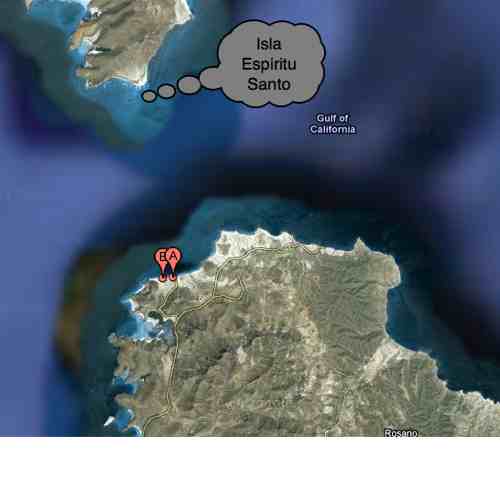
Google maps

I’d been here several times in the past, most memorably on my kayak tour of the island (PHOTOS).

You can walk anywhere in this desert. I headed east along the shore, like Graham MacIntosh. Here’s a view looking back to Tecolote.

The highlight is sea birds. Especially Pelicans.

This little lizard is the only other beast I saw.

Seems the area has many wild burros. They were all around. But I never saw even one.

Perhaps the ATVs scare them away.

Here’s the ferry La Paz – Mazatlan.

There are plenty of ramshackle fishing shacks along the coast. Most empty.

I decided to head inland to tent.

Perfect weather, I enjoyed a peaceful sunset and sunrise. Someone had previously tented up here, already clearing a spot.

In the arms of that cactus near my tent, I left a Summit Stone.

Deserts are some of my favourite hikes. But you cannot go out long. Drinking 4 litres, I was already thirsty after 21 hours.

See the rest of my photos from this hike.
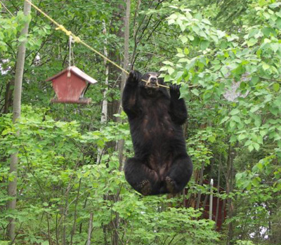
President Palin did something STUPID

OK, it’s a slow news day.

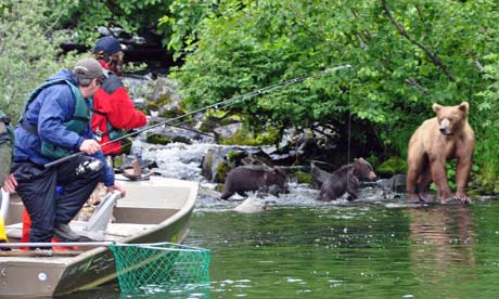
In her television show tonight, Sarah Palin casts herself as a can-do superwoman of the natural world. She fishes, hikes across glaciers and preaches “respect for the elements” from a speedboat while clad in a yellow cagoule. But the programme has already plunged the Mama Grizzly-in-chief into controversy after a leading conservationist in her adopted home of Alaska accused her of flagrant irresponsibility by fishing too close to protected brown bears. …

Find out whether she survived the encounter on Guardian – Sarah Palin accused of breaking countryside rules in TV nature show

protecting the Great Bear Rainforest

After reading The Adventure Blog – Update On Great Bear Rainforest Expedition I dug in and did some research.

I’m all for developing the Alberta Oil Sands. (I live in Alberta.) But it sounds like this is not the best way to transport it to China.

Click PLAY or watch it on YouTube.

… International League of Conservation photographers in the Great Bear Rainforest.

… now threatened by a proposal from Enbridge to bring an oil pipeline from the Tar Sands and supertankers to BC’s wild coast. …

What do you think?

… In a preface to your comments on how you don’t like dirty oil, let us know whether or not you drive a petroleum fueled vehicle.

Grey Mountain, Whitehorse, Yukon

Whitehorse is the capital of the Yukon, Canada.

A popular day hike is the scramble from the parking lot at this tower up to one of the Grey Mountain summits overlooking town.

Grey Mountain, Whitehorse, Yukon

Autumn is the best time, I reckon.

Grey Mountain, Whitehorse, Yukon

Grey Mountain, Whitehorse, Yukon

The best guidebook, available from Tourist Information, is “Whitehorse & Area Hikes & Bikes” by Harbour Publishing. It describes the longer, tougher climb on foot from the city. (403m elevation gain, 7km return)

… I drove up.

Dall Sheep in Kluane National Park, Yukon

The former hunting ground for the Southern Tutchone peoples is now a No Harvest Zone.

Today, Tachäl Dhäl (Slim’s River) is a popular Dall sheep viewing area. I saw many, many when I was in Kluane in September.

hiking Slim's River West, Yukon (A'äy Chù)

hiking Slim's River West, Yukon (A'äy Chù)

The best hike to shoot these magnificient alpine beasts (with your camera) is … Sheep Mountain. (aka Sheep Creek)

related – Parks Canada – The Dall Sheep of Tachäl Dhäl

wolf watching in Yellowstone

The Adventure Blogger posted his recent adventures with wolf guru park ranger Rick McIntyre.

And also posted an account on Gadling:

… In 1995, 70 years after the last wolf has been spotted in the park, a controversial plan was announced to reintroduce wolves to Yellowstone. Experts saw them as vital to managing the overall health of the park’s ecosystem, which had seen its elk herds grow to record numbers, unchecked by any natural predators. Meanwhile opponents to the plan feared that the wolves would wander out of the park and once again raid the livestock of ranchers. It turns out both parties were right …

Tracking the various wolf packs of Yellowstone is quite a job, as they are regularly on the move and prefer to stay well hidden from prying eyes. They all have their own territories however, which helps to define their locations to a degree, so if you are traveling through Yellowstone, it is worth the time and effort to see if you can spot them in the wild. Be sure to bring a good pair of binoculars or a spotting scope of your own …

Gadling – Spotting wolves in Yellowstone

Coincidentally, I saw my first wolf there a few days earlier. At night, in the dark, one lingered beside the highway looking at my vehicle before slipping away down slope.

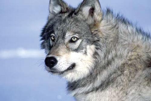
I didn’t have time to get a photo. But I’ll pretend this one is mine:

Wolf Watcher

hiking Maroon Bells Loop, Colorado

trip report by besthike editor Rick McCharles

• 28mi (45.1km)
• moderate difficulty
• free backcountry permit
• 4 passes all higher than 12,000ft

For years I’ve wanted to get to this, one of the most photographed idyls in the Rockies.

Maroon Lake

The Maroon Bells is a mountain in the Elk Mountains that consists of two peaks, South Maroon Peak and North Maroon Peak, separated by about a third of a mile.

… about 12 miles southwest of Aspen. Both peaks are counted as fourteeners …

The Maroon Bells 4 Pass Loop starts here, high at 9580ft (2920m), mostly above the treeline.

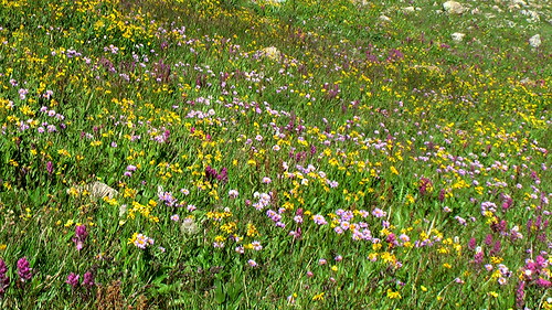
The wildflowers were still quite good mid-August.

Maroon Bells 4 Passes Hike

As usual in late afternoon in the Rockies, weather was iffy.

Maroon Bells 4 Passes Hike

It was an emergency tent site I finally found just at dark. Happily, next morning dawned brilliantly clear:

morning from the tent - Maroon Bells 4 Passes Hike

Early morning I crossed pass #1: West Maroon.

Maroon Bells 4 Passes Hike

En route to Pass #2: Frigid Air:

Maroon Bells 4 Passes Hike

The trails are fantastic, … aside from one much cursed section I called THE QUAGMIRE. Once you reach the biggest waterfall on the Crystal river, the track disappears into a bog of mud and fallen trees.

Who’s responsible?

Here I am cleaning my shoes (deliberately) on a creek crossing.

Maroon Bells 4 Passes Hike

When I met an oncoming hiker who had heard about THE QUAGMIRE, he decided to bushwhack on the opposite side of Crystal river. It couldn’t possibly be worse.

See the next high pass?

Maroon Bells 4 Passes Hike

That’s #3, Trail Rider.

It was a long, exhausting climb. Yet gorgeous.

Maroon Bells 4 Passes Hike

Hikers on Trail Rider pass:

Maroon Bells 4 Passes Hike

The vistas of Snowmass Lake on the other side were all that was keeping me going.

Maroon Bells 4 Passes Hike

Tenting is super popular at Snowmass. I decided to carry on until dusk, approaching the 4th and final pass. …

Next morning I was up at first light, first human at pass #4 Buckskin. It was just me and the mountain goats.

mountain goat - Maroon Bells 4 Passes Hike

I’ll always remember the big open vistas of the Maroon Bells. And the wildflowers.

Maroon Bells 4 Passes Hike

Highly recommended. One of the best hikes in the world.

Rick at Maroon Lake, Colorado

see the rest of my photos