hiking Tecolote Beach, Baja

trip report by site editor Rick McCharles

Tecolote (A) is an isolated beach community located in the municipality of La Paz in the state of Baja California Sur, It is 25 km from the city of La Paz …

It is one of the most extensive of the beaches in this area with fine, white sand gentle waves and little undertow. Water skiing and jet skiing are available here as well as a boat that goes to Isla Espíritu Santo.

Google maps

I’d been here several times in the past, most memorably on my kayak tour of the island (PHOTOS).

You can walk anywhere in this desert. I headed east along the shore, like Graham MacIntosh. Here’s a view looking back to Tecolote.

The highlight is sea birds. Especially Pelicans.

This little lizard is the only other beast I saw.

Seems the area has many wild burros. They were all around. But I never saw even one.

Perhaps the ATVs scare them away.

Here’s the ferry La Paz – Mazatlan.

There are plenty of ramshackle fishing shacks along the coast. Most empty.

I decided to head inland to tent.

Perfect weather, I enjoyed a peaceful sunset and sunrise. Someone had previously tented up here, already clearing a spot.

In the arms of that cactus near my tent, I left a Summit Stone.

Deserts are some of my favourite hikes. But you cannot go out long. Drinking 4 litres, I was already thirsty after 21 hours.

See the rest of my photos from this hike.

Jeju Olle hike, Korea day 5

#Jeju #JejuOlle

trip report by site editor Rick McCharles

Day 1 | 2 | 3 | 4 | 5 |

Day 4 had been long long, over 30km. In the dark I lucked into finding a perfect tent site, hidden away in a rock niche high above the coast.

Route 5-6 - Jeju Olle, Korea

It had previously been used as a meditation retreat.

Route 5-6 - Jeju Olle, Korea

Dawn is the most peaceful time of the day. They are not early risers on Jeju.

Route 5-6 - Jeju Olle, Korea

Locals live by the “Sam Mu” (“Three Nothings”) – no beggars, no thieves, no gates.

Route 5-6 - Jeju Olle, Korea

Here is (by far) my favourite restaurant over 100km – the Two Weeks Coffee Shop.

Two Weeks Coffee Shop

The owner retired from Seoul. Because he and his wife love coffee, they purchased the property to set up a retirement job.

Two Weeks Coffee Shop - bicycle construct

Every Korean can guess why it’s named Two Weeks. … You’ll have to go yourself and ask if you want to know. Bring a book and a laptop. They have free WiFi. You can hang out in their lovely garden.

Two Weeks Coffee Shop

Check the vista from atop the nearby cinder cone.

vista from Two Weeks Coffee Shop

Known as an “oreum” (lateral volcano grown over as a hill or small mountain), the Jeju Olle never bypasses one without making you climb to the top.

Route 5-6 - Jeju Olle, Korea

That’s the second largest “city” on Jeju, Seogwipo.

Route 5-6 - Jeju Olle, Korea

They have the same huge, colourful web spiders I’ve bumped into many times in Hong Kong.

Route 5-6 - Jeju Olle, Korea

I imagine these small, timid feral cats eat the spiders, when they can.

Route 5-6 - Jeju Olle, Korea

I finished at the official Jeju Olle office in Seogwipo, a bit disappointed that I ran out of time to do route 7. Some feel that’s the best of all.

Read more about route 6 on the official website.

See the rest of my route 5-6 photos on flickr.

Day 1 | 2 | 3 | 4 | 5 |

_____

Resources if you want to plan a trip for yourself:

Visit Korea – Jeju Olle (also available in many other languages)

JejuOlle.org (also in Japanese, Chinese and Korean)

Wild Junket – Hiking in Korea: Jeju Olle Trail

Though I did not use it, there is a guidebook in English. Look for it on the island or check it out as a PDF linked from this Visit Korea page.

Questions? Suggestions? … Leave a comment.

Jeju Olle hike, Korea day 4

#Jeju #JejuOlle

trip report by site editor Rick McCharles

Day 1 | 2 | 3 | 4 | 5 | (routes 1→ 6 = 106km)

This page recounts routes 4 and 5.

An early start again, the Festival tents were not yet open. So I missed a couple of passport stamps.

One town had entertainment for those of us in the Walking Festival. For example, here is a traditional drummer.

Route 4-5 - Jeju Olle, Korea

Everywhere you turn on Jeju island you’ll see reminders that this is a nation prepared for war. Most military installations are unmanned, but covered in camouflage.

Route 4-5 - Jeju Olle, Korea

On the trail the military has posted photos, including this one.

Route 4-5 - Jeju Olle, Korea

We visitors were all charmed by the local dogs of the island. Very mild mannered, they rarely even bark. It seemed perhaps 70% of the pet dogs were of this one breed.

Route 4-5 - Jeju Olle, Korea

Slippery sections of the Jeju Olle are improved with these recycled tire mats.

Route 4-5 - Jeju Olle, Korea

The foreign experts were not impressed. What happens when they (inevitably) break up?

Route 4-5 - Jeju Olle, Korea

An inland section routes past an impressive Buddhist monastery.

Route 4-5 - Jeju Olle, Korea

I didn’t take the time to visit. But it seemed to be welcoming to hikers.

Route 4-5 - Jeju Olle, Korea

The biggest crop at this time of the year is Mandarins.

Route 4-5 - Jeju Olle, Korea

But many others were being taken off the fields. Several different grains were drying.

Route 4-5 - Jeju Olle, Korea

I was a little surprised how undeveloped the coastline is … for an island so based on the fishery.

Route 4-5 - Jeju Olle, Korea

Linda Myers estimates 30,000 walked one of the Jeju Olle pathways in 2008. And 150,000 in 2009. That will have grown again in 2010, yet it never feels crowded.

Route 4-5 - Jeju Olle, Korea


Read more about route 4 on the official website.

Read more about route 5 on the official website.

See the rest of my route 4 & 5 photos on flickr.

Day 1 | 2 | 3 | 4 | 5 | (routes 1→ 6 = 106km)

Jeju Olle hike, Korea day 3

#Jeju #JejuOlle

trip report by site editor Rick McCharles

Day 1 | 2 | 3 | 4 | 5 | (routes 1→ 6 = 106km)

I did part of this route with the Walking Festival. And came back later by myself, to finish.

Route 3 - Jeju Olle, Korea

Walking in Korea and most of Asia is traditionally for the purpose of religious pilgrimage. To walk for fun and fitness is a relatively new and foreign concept.

Festival motto – be happy on the trail

Route 3 - Jeju Olle, Korea

Perhaps the most amazing sight on the sections I hiked was this vast area covered with Mandarin orange peels. We were told that, once dried, it would be used in tea.

Route 3 - Jeju Olle, Korea

The aroma was wonderful.

It was here, too, that our hiking group sampled the famous Jeju pork. Delicious.

Route 3 - Jeju Olle, Korea

Of the stretches along the water, I think this was my favourite.

Route 3 - Jeju Olle, Korea

Near the coast there are always surf cast fishermen in sight.

Route 3 - Jeju Olle, Korea

Most of the “beaches” are black and stony …

This one, Pyoseon, near our official Conference hotel was a rare sandy treat

Route 3 - Jeju Olle, Korea

We took a shortcut to the finish

Route 3 - Jeju Olle, Korea

Christian funeral monument.

Route 3 - Jeju Olle, Korea

Korea is about 40% Christian though none of the huge churches you’ve seen on TV are located on Jeju.

Route 3 - Jeju Olle, Korea

One of the bloggers saw some of the famous diving women of the island close to here.

It’s an interesting story, those divers.

Another saying of this island is that “rocks, wind and women are plentiful“. It’s a bit of a matriarchal society.

Haenyo are skilled divers who are known to be able to hold their breath for more than two minutes and dive to depths of 20 meters. Diving was the first profession for women in Korea and the Haenyo are some of the best free divers in the world.

Route 3 - Jeju Olle, Korea

I set up a tent in a spot hidden by tall grasses. This, my only companion, didn’t reveal I was there.

Route 3 - Jeju Olle, Korea

Read more about route 3 on the official website.

See the rest of my route 3 photos on flickr.

Day 1 | 2 | 3 | 4 | 5 | (routes 1→ 6 = 106km)

Jeju Olle hike, Korea day 2

#Jeju #JejuOlle

trip report by site editor Rick McCharles

Day 1 | 2 | 3 | 4 | 5 | (routes 1→ 6 = 106km)

I did this section solo, starting very early morning. There wasn’t much of a sunrise over Sunrise Peak.

Route 2 - Jeju Olle, Korea

We’ve categorized this a coastal trail as it more often than not stays near the shoreline, moving inland to visit highlights.

Route 2 - Jeju Olle, Korea

Most walk in the normal direction, colour coded Blue. But if you wanted to meet more people, there’s no reason not to walk it backwards, following the Orange signage.

Route 2 - Jeju Olle, Korea

The world “Olle” comes from an old local dialect of Korean. It can be translated as “a very narrow path from house to the closest road”.

The philosophy of the trail builders was to find existing, sometimes disused, pathways less than 1m wide. And to rejuvenate them.

That’s the ideal. In reality, the need to keep the route close to buses and toilets results in paved surfaces perhaps 70% of the route. My feet were bruised and sore after 100km.

Route 2 - Jeju Olle, Korea

Still, there’s rarely much traffic. Jeju island is ideal for road biking though that’s not yet caught on. i did see perhaps a couple dozen recreational mountain bikers over the week I was there.

There’s no official policy regarding cycling the Jeju Olle. But organizers will try to discourage it. (They can’t ban bikes as most of the trail is on public roadways.)

Route 2 - Jeju Olle, Korea

Shout out to the many volunteers at the Walking Festival. It was a great pleasure to arrive at each tent to get my passport stamped, get water, and recharge my enthusiasm.

Traditional stone figures are common on Jeju. … Next time I’m going to learn the significance of each.

Route 1 - Jeju Olle, Korea

They are proud of their beautiful turnips on Jeju.

Route 2 - Jeju Olle, Korea

Route 2 - Jeju Olle, Korea

I didn’t research insects. One morning in wet grass I did see mosquitos. They did not pester.

Route 2 - Jeju Olle, Korea

If you can live on “Mandarin oranges“, you need not carry any food in November. It’s harvest time. Every farmer wants you to try some of his.

Route 2 - Jeju Olle, Korea

One of the more lovely sections this day …

Route 2 - Jeju Olle, Korea

Read more about route 2 on the official website.

See the rest of my route 2 photos on flickr.

Day 1 | 2 | 3 | 4 | 5 | (routes 1→ 6 = 106km)

vote Jeju – 7 Wonders of Nature

#Jeju #JejuOlle

I spent 4 days hiking the lovely Jeju Olle Trail in Korea. At the very start of the intended 339km (and growing) walking path is Sunrise Peak (Seongsan Ilchulbong).

Very weird. Unique in the world. I found it fascinating. See more interesting photos tagged Seongsan.

Jeju is a small, rural island. And a popular tourist destination in Asia. Yet it’s not well known outside Asia.

Jeju Island 제주도

Let’s correct that by voting Jeju Island to the new list of 7 Wonders of Nature. The island is already listed a World Heritage Site: Jeju Volcanic Island and Lava Tubes.

Here’s an instructional video explaining how to vote for your top 7. (You need choose your 7 wonders first, before registering.)

related: Visit Korea – Jeju Olle

hiking in Jeju, Korea

by site editor Rick McCharles

We’ve completed the 3 day “World Trail Conference”, superbly presented for a first ever event. In Asia they really know how to do conventions. Kudos to organizers.

I’m off the next few days hiking the Jeju Olle trail as part of the walking festival.

hiking the Cinque Terre, Italy

trip report by site editor Rick McCharles

Though Buzz of the Adventure Running blog disparaged the Cinque Terre as a … “girlfriend hike”, I loved it. As does almost everyone.

Alas, I had no lass.

I walked the Cinque Terre, solo.

Since it was my first time there, I did the classic Sentiero Azzurro (Trail #2) route. (Or Blue Path or Azure Path or Light Blue Path)

12km (7.5mi)
Riomaggiore to Monterosso al Mare
easy with difficult sections, some exposure

Lonely Planet Hiking in Italy:

There’s a reason why the Sentiero Azzurro is one of Italy’s most crowded trails, and the only one you’ll have to pay cash to enter. …

… the route follows an ancient network of walking paths that has linked the five Cinque Terre villages together for over a millennium.

Studded with panoramic vistas, it traverses windswept olive groves and seemingly impregnable vineyards, before dipping serendipitously into each of the flavourful maritime villages …

It starts with a jolt. Check out the first village, Riomaggiore.

Cinque Terre hike, Italy

I picked up some wonderful fresh bread in a bakery here.

Cinque Terre hike, Italy

Next up, Via dell’ Amore … Does that translate to Way of Love?

Cinque Terre hike, Italy

Lonely Planet should have encouraged me to bring a love lock and some spray paint for tagging. 🙂

Love padlocks - Cinque Terre hike, Italy

Love padlocks - Cinque Terre hike, Italy

graffiti - Cinque Terre hike, Italy

I did meet one goddess on the trail.

Cinque Terre hike, Italy

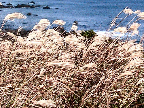
Wow. The scenery was stunning, even on an overcast day.

Cinque Terre hike, Italy

Vernazza was my favourite of the five towns. Gorgeous.

Cinque Terre hike, Italy

Cinque Terre hike, Italy

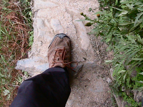
Check how narrow the footpath is at this point. (And it’s a long drop if you misstep.)

Cinque Terre hike, Italy

It was much later in the afternoon than I expected when finally arriving in the last village, Monterosso al Mare.

Cinque Terre hike, Italy

But I’d highly recommend you continue through town to check out a truly interesting building / statue – The Giant.

You can’t miss it.

Though the Cinque Terre is crowded, everyone loves this walk. (But you’ll love it more if you bring someone special along.)

There are other great trails, too. Next time I’ll go for either the Sentierro Rosso (38km) or, even better, the Promotario de Portofino Circuit (18km). I’ll stay in one of the two hostels on the coast, booking weeks in advance to be sure of space.
_____

… Wait a minute. I did have a girlfriend in nearby La Spezia. Her name is Hotel Diana.

Diana Hotel - La Spezia, Italy

Expensive at 60EU / night, the most I paid for it in Italy.

See the rest of my photos from this hike.

Pathway of the Gods, Amalfi, Italy

trip report by site editor Rick McCharles

aka Path of the Gods and Walk of the Gods

Agerola to Positano, 2 ½ to 3 hours

In Naples I couldn’t find a copy of Lonely Planet Hiking Italy. … Instead, I jotted down some trail notes from the internet. And jumped on a bus to “Amalfi”.

I jumped off the bus upon seeing a sign for “Sentiero degli Dei“ (Pathway of the Gods).

Where was I? … Piazza Paolo Capassa, the sign said. A tourist information office in that plaza gave me a crude map. I was set.

Path of the Gods, Amalfi, Italy

Here’s the start from that trailhead.

Path of the Gods, Amalfi, Italy

It wandered through vineyards.

Path of the Gods, Amalfi, Italy

Though the ancient trail has been improved much over the centuries, I’d still call it a “difficult” hike.

Path of the Gods, Amalfi, Italy

I left a Summit Stone atop this tombstone pillar, under a sign posted by the Club of Italian Alpinists.

Approaching Positano, the cliffs got steeper and steeper.

Path of the Gods, Amalfi, Italy

I saw about a dozen other hikers on a perfect day in October. All spoke either English or German.

Path of the Gods, Amalfi, Italy

SAY WHAT … !!

Path of the Gods, Amalfi, Italy

My legs were wobbly by the time I got to the bottom, finally arriving in Positano.

Path of the Gods, Amalfi, Italy

Path of the Gods, Amalfi, Italy

The most dangerous section of the Path of the Gods, by far, is walking narrow roadways from the Positano trailhead up to the excellent Brikette hostel.

La vita è bella.

The Path of the Gods is one of the best hikes in the world.

See the rest of my photos. Or watch a short video of the hike.