Colorado Trail in 6 Minutes

This video is a short montage that summarizes the highlights of the Colorado Trail, which allows you to have a good idea of โ€‹โ€‹what you will see, hoping that it gives you the taste to hike it in section or in full! …

Challenge yourself with exhilarating hikes, heart-pumping mountain biking sessions, or test your endurance by backpacking along the trail’s magnificent 500-mile length.

โ€ขTime Needed to complete the whole CT: 29 days

โ€ขHighest Elevation: 13,334 ft. – Coney Summit

โ€ขLowest Elevation: 5,520 ft. – Waterton Canyon

โ€ขElevation Gain (approx.): 89,000 ft.

– Ratatrail

Click PLAY or watch it on YouTube.

related – Clever Hiker – A Complete Guide to Hiking the Colorado Trail

If you want more, check our Colorado Trail information page.


RAIN on the Milford Track, New Zealand

Michael Lanza, family, and friends hiked the โ€œFinest Walk In The Worldโ€ in 2025.

They went hut-to-hut, the guided option. The easiest way to get a permit on that famous walk.

Lanza posted a terrific trip report and put together an up-to-date eBook on how to organize this adventure for yourself.

LEARNING TOโ€”LOVE?โ€”THE RAIN ON NEW ZEALANDโ€™S MILFORD TRACK

Check our Milford Information page for more.

Timberline Trail – around Mt Hood

Clever Hiker updated details in 2024:

Timberline Trail Backpacking Guide

  • Distance:ย 38.3-mile loop
  • Time Needed:ย 3-4 days
  • Highest Elevation:ย 7,350 ft. Timberline High Pointย 
  • Lowest Elevation:ย 3,300 ft. Near Ramona Fallsย 
  • Elevation Gain (approx.):ย 9,000 ft.
  • Best Time to Hike:ย July-September
  • Permits:ย Yes (May 15th to October 15th)
  • Difficulty:ย Challenging

Permits

Permits are required for overnight trips on the Timberline Trail from May 15th to October 15th, but they are free and can be found at trailheads around Mt. Hood. Simply fill one out before you hit the trail. Some trailheads do require a Northwest Forest Pass for parking.


Jon posted a detailed trip report on their August 2019 circuit of Oregonโ€™s highest peak. It’s close to Portland.

This report is all you need to organize that adventure for yourself.ย 

Plenty of climbs and descents. Quite a few creeks crossings. Not what we’d call an easy week.

They started and ended at Timberline Lodge. And hiked clockwise.

The report includes excellent photos so you really get a feel for what to expect.

Mount Hood (photo credit: Dan Nevill, CC 2.0)
Ramona Falls (photo credit: Dan Nevill, CC 2.0)

Check it out:

TIMBERLINE TRAIL โ€“ MOUNT HOOD WILDERNESS, OR (40 MILEย LOOP)

ย 
Similar adventures in the Pacific N.W. include the Wonderland Trail around Mt Ranier and / or a partial circuit around nearby Mt Adams.

#9 Hiking Town โ€“ Zermatt, Switzerland

This resort is off-putting to some. Ignore the posturing Eurotrash, conspicuous in brightly coloured expensive outdoor apparel, unsoiled. ๐Ÿ˜€

Instead, turn your gaze up to the Matterhorn, “iconic emblem of the Swiss Alps and the Alps”. This valley is one of the great natural wonders of the world.

Zermatt … is in the German-speaking section of the canton of Valais in Switzerland. It has a population of about 5,800 inhabitants.

The village is situated at the end of Mattertal at an altitude of 1,620 m (5,315 ft), at the feet of Switzerland’s highest peaks. …

Zermatt is famed as a mountaineering and ski resort of the Swiss Alps. …

To prevent air pollution which could obscure the town’s view of the Matterhorn, the entire town is a combustion-engine car-free zone. Almost all vehicles in Zermatt are battery driven and almost completely silent. Electric vehicles are allowed for local commerce. …

More interesting photos tagged Zermatt, Switzerland.

Our favourite hike hikes out of Zermatt:

โ€ข Chamonix to Zermatt – Walkers’ Haute Route TOP 10 <guidebook> <trip>
โ€ข Tour of the Matterhorn
โ€ข Tour of Monte Rosa

Weisshorn 4506m from the Europa Hut at sunrise

Actually, there are trails everywhere in the Alps. It’s awesome.

View from Weisshorn

More best hikes in the Alps.

Best time to hike is late June to early October.

Click PLAY or watch a 1 minute preview on YouTube. 

#4 day hike – Laguna de los Tres, Argentina

One of our top 10 day hikes in the world.

Why?

The photos say it all. ๐Ÿ˜€

  • our pick for best day hike โ€” of many โ€” out of El Chaltรฉn, Argentina’s Trekking Capital in Patagonia
  • the nearest airport is El Calafate
  • November – March are the best months. You might have snow on the trail in November or March, however.
  • 8+ hours round trip depending on route
  • elevation gain 2,300 ft. (700m)
  • option to tent near the lake
  • infamous for bad weather. Be prepared for extreme wind.

World โ†’ S America โ†’ Patagonian Andes โ†’ Argentina โ†’ Laguna de los Tres

vista from El Chaltรฉn

For details click over to our Laguna de los Tres information page.

Permit for the Wonderland Trail, Washington State

Without question, Wonderland is one of the best hikes in the world.

I’ve been only once in 2010. Fantastic.

Theย Wonderland Trailย is an approximately 93-mile (150ย km) hikingย trail that circumnavigatesย Mount Rainierย inย Mount Rainier National Park,ย Washington

An estimated 200 to 250 people a year complete the entire trail with several thousand others doing shorter sections of it.ย …

Milissa (aka Mary Poppins) and Lady on a Rock got a permit by showing up early at the ranger station on a Monday morning with no specific expectations and took whatever was available.

Read the TRIP REPORT:

HIKE THE WONDERLAND TRAIL: A JOURNEY AROUND MOUNT RAINIER

Hiking the Southernmost Trail in the World

Kraig Adams and 2 friends hiked the Dientes de Navarino trail, Chile, March 2025.

It’s more of a route than a fixed trail. Bushwhacking required.

FIRST โž™ make your way to Puerto Williams, Chile.

Kraig’s is the best video I’ve seen yet of that remote adventure. I tried and failed to complete the Circuit myself in 2019.

The trail was covered over with snow, and I had no guide to lead the way. I only tented one night. Awoke with a a bad stomach ache. Then turned back.

AT A GLANCE

  • world’s most southerly major hike?
  • circumambulate the jagged spires of Cordon de los Dientes
  • out of Puerto Williams, Chile, on Isla Navarino (pop. 2,262 last time we counted)
  • recommended 5 days, 4 nights in the past. Most hikers are doing it in 4 days, 3 nights now as the route is betterย cairned and signed. Kraig did it in 3 days, 2 nights.

To find out how to do this trip yourself, click over to our Dientes Circuit information page.

Click PLAY or watch it on YouTube.

#8 Hiking Towns โ€“ El Calafateย /ย El Chaltรฉn, Patagonia

All hikers plan, one day, to travel to southern Patagonia. Towers of Paine photos entice.

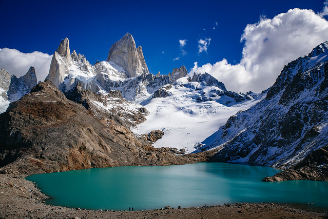
And anyone who hikes Paine, should also hike Fitz Roy, Argentina.

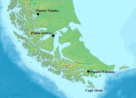
Hikers have a choice to base themselves out of Puerto Natales, Chile or El Calafate, Argentina. Though you may find yourself stopping in both, El Calafate is the better choice.

El Calafate is a small town in Patagonia, Argentina. …

… an important tourist destination as the hub to visit different parts of the Los Glaciares National Park, including the Perito Moreno Glacier (one of the most visited in the world) and the Cerro Chaltรฉn and Cerro Torre.

… In the last census 6,143 permanent residents were counted

You could argue thatย El Chaltรฉn, Argentina’s “national trekking capital“, about 220km from El Calafate, is an even better base town.

On the other hand, there are large grocery stores like Diarco in El Calafate. The shops in Chaltรฉn in 2019 were still very limited. We couldn’t get instant mashed potatoes in Chaltรฉn, for example. Pick up your provisions in Calafate.

And Calafate is about half way between Paine and Fitz Roy.

More interesting photos tagged El Calafate, Argentina.

More information on Wikitravel – El Calafate.

Our favourite hike hikes out of El Calafate:

โ€ข Paine Circuit (Torres del Paine), Chile

โ€ข Huemul Route, Fitz Roy, Argentina

โ€ขย Around Monte Fitz Roy (Los Glaciares), Argentina

These are the most famous, but there are many more “best hikes” in the Patagonian Andes. Ground transportation is the biggest challenge in this part of the world.

Best months are December to March.

Top 10 Hiking Destinations โž™ Patagonian Andes

Patagonia is massive and bleak. Yet we love the Patagonian Andes, 2000km (1243mi) in length, but averaging less than 100km (62mi) in width. You could take years exploring just the eastward (drier) side of the mountains.

Towering granite peaks, untouched lakes, massive glaciers, huge volcano trekking peaks. This land is phenomenal.

Mirador del Pliegue Tumbado, Fitz Roy, Argentina

Trekkers target five areas:

  • The Araucania
  • Lakes District
  • Central Patagonia
  • Southern Patagonia
  • Tierra del Fuego

Start in Mendoza, Argentina and visit the highest mountain outside Asia, Aconcagua. Next bus to the Switzerland of South America (Lake District). Some of the highest volcanoes of the world are here. Finally, work your way south by air and ferry to the granite spires at the south tip of the continent.

Trekking season here is Nov-Apr. (Feb-Mar often the best weather) That said, the wind and weather in Patagonia is notorious. Independent hikers need be prepared for anything and everything.

Conversational Spanish highly recommended for those travelling independently.

More information on our new Patagonia information page.

Our favourite hike in the Patagonian Andes is the Paine Circuit in Chile.


John Grey Pass, Paine Circuit – flickr – Patagonia set – Michael Bollino

See our Paine Circuit Information page.

Our original hiking bible is the now discontinued Lonely Planet Trekking in the Patagonian Andes:

Lonely Planet Trekking in the Patagonian Andes

Queenstown, New Zealand – Adventure Capital of the World

Queenstown is one of our top 10 hiking towns in the world.

Jumping off point for …

โ€ขย Milford Track
โ€ขย Routeburn Track
โ€ขย Kepler Track

There’s MUCH more to do in Queenstown, however.

Click PLAY or watch it on YouTube.