Yes it’s windy in Patagonia.
And increasingly difficult to organize. Check our Paine information page for details.
Click PLAY or watch it on YouTube.
Yes it’s windy in Patagonia.
And increasingly difficult to organize. Check our Paine information page for details.
Click PLAY or watch it on YouTube.
by BestHike editor Rick McCharles
UPDATE. As of April 1, 2023 the Nepal government required that major treks can no longer be done independently. Hiring a guide for Everest is mandatory. The obvious alternative is the Indian Himalaya. We’ll leave this post PUBLISHED in case the government reverses this policy sometime in future.
December 2019. I’m just back from Nepal, my first trip since 2014 where I hiked Langtang.
Around 9,000 people died during the Nepal earthquake of 25 April 2015.
One tiny village in the Langtang Valley accounted for 243 of them: 175 villagers, 27 local tourism staff (guides and porters), and 41 foreign trekkers.
Yet in the 2018-19 fiscal year, a record 21,945 tourists (16,386 foreigners and 5,559 Nepalis) visited Langtang National Park.
So far as I could see, Nepal trails are busier than ever. And easier than ever as you could connect to the internet almost everywhere with a Nepal Telecom (Namaste) SIM card in my mobile phone. I didn’t once have to pay for electricity in the mountains.
The big 3 trekking areas for those who want to hike independently are

We love Nepal because it’s so easy and inexpensive to access many of the best hikes in the world.
Hiking other Himalayan nations is problematic for different reasons: Bhutan, China, Tibet, India, Pakistan, Afghanistan.
On the other hand, arriving in Kathmandu or Pokhara you are faced with a bewildering number of options. 😐
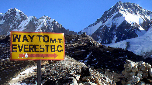
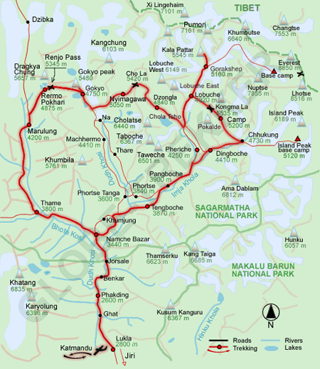
If you can only do one hike in Nepal it should be Everest Base Camp 3 Passes:
Kongma pass (5,535m)
Cho pass (5,380m)
Renjo pass (5,388m)
Plus Kala Pattar peak (5,545m) and Base Camp (5,380m).
Ideally you’d want 3 weeks. Two weeks would be risky in terms of rushed acclimatization.

The classic trek is the Annapurna Circuit. But but road construction has degraded the experience.
Though still popular in 2019, the Circuit now might be better for mountain biking than hiking.
Best of the alternatives is another classic:
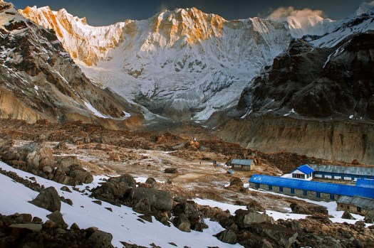
Annapurna Sanctuary (ABC)
OTHER alternatives somewhat similar to ABC include:
Khopra Ridge (opened 2012)
Mardi Himal

Ideally, we’d love to do one continuous hike:
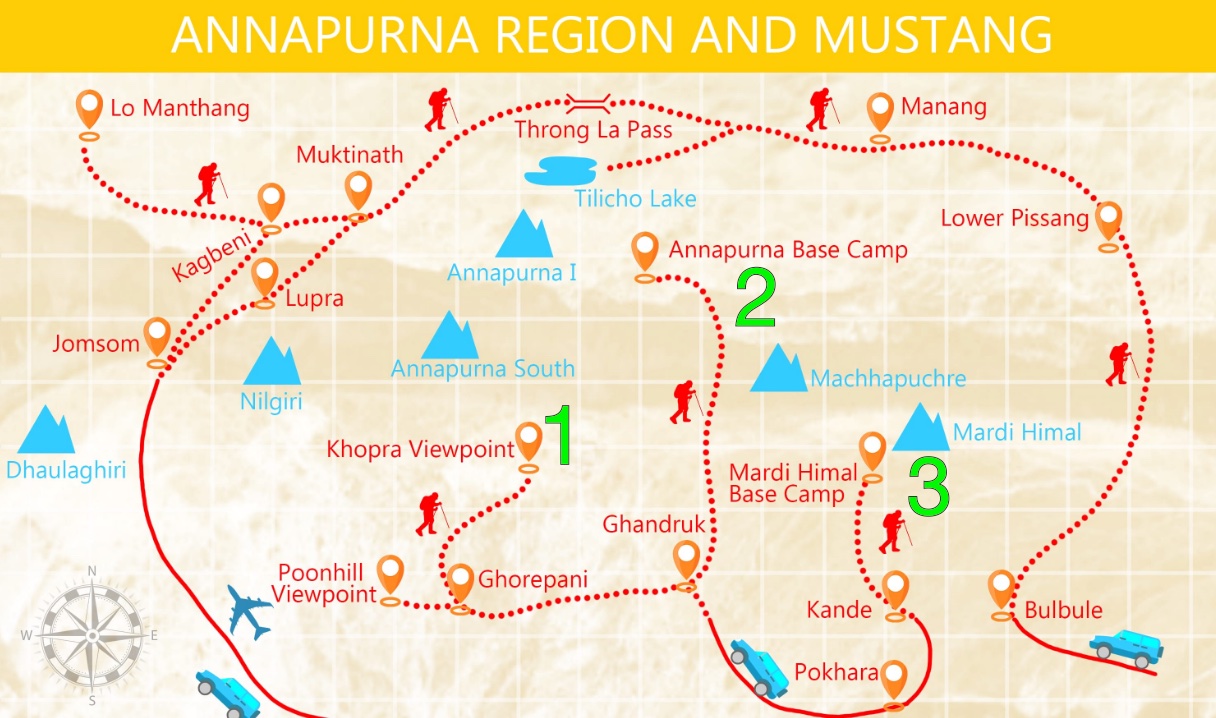
Annapurna Dhaulagiri Community Trek starting Banskharka (Bans Kharka) to acclimatize → continuing on 1. Khopra Ridge → connecting to 2. Annapurna Sanctuary (ABC) → finishing with 3. Mardi Himal .
The 2-3 week adventure in green connecting those 3 hikes would be far more enjoyable than the Annapurna Circuit.
You can do all on the same permit.
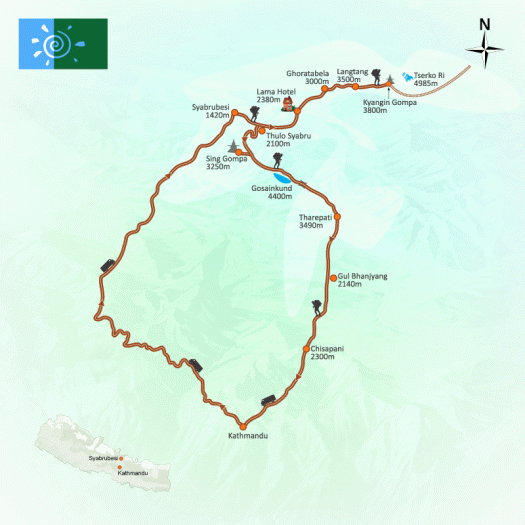
Our recommended route. Perhaps 14-16 days.
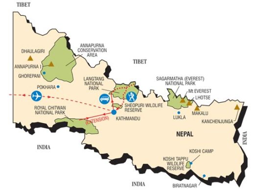
Drive to Syabrubesi, trekking Langtang first (top of the map). Then backtracking to the Gosainkund & Helambu trek, walking most of the way back to Kathmandu.


This will be far less crowded than either Everest or Annapurna regions.
You can easily and inexpensively hire a guide and/or porters on any hike in Nepal for your whole trip … or short sections. But we’d recommend you do those listed above independently.
If we were to do a guided hike we’d choose areas of Nepal where guides are mandatory. For example:
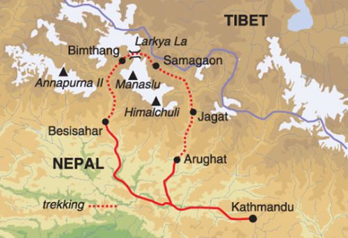
The Manaslu Circuit (lodges open since 2010) was fantastic and uncrowded before the 2015 earthquake. Reports are that it’s fantastic again in 2019.
The Tsum Valley sidetrip is still a recommended add-on in 2019. But China is developing a road. It could be a dusty construction zone soon.


Manaslu finishes on the Annapurna Circuit. In 2013 I did Manaslu with a guide — then continued independently on the Circuit hiking & cycling.
Since I was acclimatized, the high pass on the Circuit seemed easy.
Questions? Suggestions? Leave a comment on this page.
Our favourite hiking destination in the Canadian Rockies is Lake O’Hara, Yoho National Park, B.C.
For decades we’ve had hikers hitting redial on the phone trying to get one of the precious reservations:
Some good news:
Overnight camping spots will now be offered through the Parks Canada reservation system on a first-come, first-served basis starting Jan. 24, 2020.
“Historically you phoned in,” …. “That creates some frustration for visitors because they get a busy signal. There was no way to see if sites were reserved.
This means we need be online at midnight on Jan 23rd.
Much easier.
Most hiking the Everest region in Nepal fly into and/or out of Lukla, a small village at 2,860 metres (9,383 ft).
You can walk in and/or out, but that requires a lot more time.

In order to ease congestion at Tribhuvan International Airport (in Kathmandu) and facilitate ongoing runway repair works … Lukla flights were rerouted to fly from Manthali.
An airport that had barely seen a dozen flights in the last decade began to handle 85 flights daily, and it was ill-equipped to deal with the hundreds of tourists arriving daily. The airport lacks proper parking, a waiting room, toilets and even a restaurant.
More than 800 tourists arrive and depart daily during peak season. About 85 flights a day.

It’s 132km (82mi) from Thamel, Kathmandu to the airport. That’s at least a a four-hour drive IF there are no delays. You leave Kathmandu around 2am.
Know that there are still a couple of Lukla flights departing Kathmandu airport after 8am each day. But it’s risky to buy that ticket as your flight might be cancelled.
Flights out of Ramechhap airport at Manthali — however — are shorter, cheaper and more reliably get you to Lukla.
The international airport in Kathmandu is terrible. Current renovations won’t help much.
The planned (2025) replacement will be situated 150kms from Kathmandu by road.
Two other new airports already under construction should help relieve traffic: Pokhara International Airport (opening 2021) and Gautam Buddha Airport. (opening 2020) should help.
I’ll try to fly into Pokhara in future. We should avoid polluted Kathmandu, if we can.
Trip report by BestHike editor Rick McCharles – day 1 | 2 | 3/4
My best ride EVER.
Jeeps and buses now shuttle up and down the valley all the way to Muktinath, causing some trekkers to dismiss this section of the Annapurna Circuit as ‘over’.
It’s not over. Most who do it still enjoy the hike down.
Still … cycling is better.
Cycling Annapurna is getting increasingly popular. But it is dangerous.
One guide I cycled alongside had 3 clients: all 3 fell over two days, one evacuated back to the U.K. with a broken collar bone.
Here’s the best easy & inexpensive option, in my opinion.
I did the Muktinath to Tatopani ride in 2014. Enjoyed it so much that I repeated exactly the same trip in 2019.
First you have to make your way to Muktinath (3800m) and be acclimatized to that altitude.
Many offer to rent you a bike. I went again with Mustang, as I like their professionalism. For this trip and 6 years ago the cost was $60 — and you could do the trip in 1, 2, 3, or 4 days for that price. Most do 2 days. They shuttle your luggage to Tatopani.
There are several ways down to Kagbeni, all interesting. This time I took the high route via Jhong (Dzong; 3580m) on the other side of the valley from the motor vehicle traffic. Loved it.
All day long you are staring at impressive Dhaulagiri (8167m).
Day 1 is dry, arid Tibetan landscape.
You definitely need protection from wind and dust.
You reach fantastic Kagbeni without passing any traffic. But road building is ongoing in the so-called Annapurna Conservation Area.
Riding through Jomsom is ugly and un-fun. But there’s no alternative to the busy main road.
Almost everyone stops in lovely Marpha. I followed the guide and her clients to this Guest House. In fact, I got the room of her injured rider.
Next morning I toured Marpha, the apple capital of Nepal.
… a pretty stone lined village which has survived the transition to the current time, by catering to trekkers and tourists. …
Dominating the village is the Nyingma monastery …
Day 2 you can often choose between the main road (bad), the river (hike-a-bike) or the new Annapurna trekking trail (single track with plenty of ups-and-downs).
I enjoyed it much better than 6 years ago.
The final ride down to Tatopani (hot water) is very, very rough. I’ll post video of that section later.
😕
BUT … it is great to hit the hot springs after 2 long, dusty days.

There’s no easy way out of Tatopani. My first time here I continued trekking to Annapurna Base Camp, a serious commitment. This time I got on the local bus … $5.50 for a 7 hour, very bumpy ride back to Pokhara.
Trip report by BestHike editor Rick McCharles – day 1 | 2 | 3/4
Waking up in Kagbeni, the morning sky was perfect.

I thought I might catch a bus or shared jeep up to Muktinath so started walking the (shockingly paved) main drag.
I ended up on foot for 3-4 hours, but still enjoyed the road walk.
The highlight was weird Serthang Selfie Park. Yep, everyone stops here to take selfies.
Happily, this viewpoint is protected from evil spirits including ZOMBIES.
I stopped too as it was my first look at massive Dhaulagiri (8167m).
Walking asphalt is super easy. And the views kept getting better.
In arid Tibetan lands these solar powered water boilers are popular.
On arrival in Ranipauwa (3710m) I went straight to Mustang Cycle to organize my bike for the next day. They recommended the newest lodge. Probably the best room I’ve had, so far.
Muktinath (3800m) is one of the holiest pilgrimage sites in the Nepali Himalaya for both Hindus and Buddhists. There are far more pilgrims than trekkers at any given time.
In the afternoon I walked up to the main temple complex above town.

Many pilgrims choose to ride horseback. Indeed, this seems the biggest industry in town.
It’s easy to get confused as to what’s a Buddhist temple and what’s a Shiva temple.
Vishnu is worshipped here as Muktinath, the Lord of Salvation, while Buddhists associate the deity with Chenresig, the Tibetan bodhisattva of compassion (yes, it’s complicated).
From there I continued over 2 suspension bridges to the village of Jhong (Dzong; 3580m) on the other side of the ‘river’.
Six years ago one huge statue of Shiva was under construction. I sat on the roof at dusk, I recall. It’s finished now.
Great views from up there.
Muktinath in November is also filled with relieved trekkers having successfully crossed Thorung La (5416m) on the Annapurna Circuit, the highest most will ever climb.
That’s it between the peaks. It snowed up there during yesterday’s crossing.
Trip report by BestHike editor Rick McCharles – day 1 | 2 | 3/4
… closely packed mud houses, dark tunnels and alleys, imposing chortens and a large, ochre-coloured gompa perched above the town. …

Click PLAY or watch a short video on YouTube.
Trip report by BestHike editor Rick McCharles – day 1 | 2 | 3/4
Nov 5, 2019 – Tadapani to Ghandruk
The end of the Khopra Ridge trek (according to Lonely Planet) is Tadapani.
Unexpected rain resulted in a power failure for most of the night.
For trekkers that means Kindle light dinner.
Did you see what I did there? 😀
As usual on this trip, next morning skies were clear.

This has been the best vista so far of my favourite peak – Machapuchare.

After evening rain, the village was washed clean.
Lodges in Nepal are very similar. There’s not much difference between yours and HOTEL MAGNIFICENT.
From Tadapani it’s easy to get back to Pokhara in a day. But I decided, instead, to spend one more mountain night in Ghandruk, a Gurung village, famed starting point for many treks.
Ghandruk was only a couple of hours downhill stroll. A very easy day for me.
Lonely Planet recommended Hotel Trekkers Inn in Ghandruk which had won many hospitality awards over the years. It’s good, but not much different than any other IMHO.
As prices are fixed at all lodges in each village, they try to match each other in features, as well.
Hotel Trekkers Inn did have good food including some menu items I’d not seen anywhere else. I tried the Moussaka … tasty, but unrelated in any way to Moussaka.
And also the local smoked, dried, spiced meat called sukuti,
In the restaurant I met a young American who will be volunteer teaching at the largest school in the area. She’ll be living at Hotel Trekkers Inn for the next 2 months.
We both met a Brit who’s an old Nepal hand. This trip he’s come to photograph the Kulung’ honey hunters‘, men who climb bamboo rope ladders to harvest the world’s largest bees. An interesting man.
Pro tip – bring a tiny luggage lock for your room. What they provide are bulky and awkward.
The Khopra Ridge Trek I just finished is excellent.
In fact, Nepal needs more like it. And there is plenty of opportunity to develop more trails in higher, less developed spurs of the Annapurna massif.
Widely circulated in local lodges is this 2014 article by Donatella Lorch who lives in Kathmandu:
… The tea-houses and lodges are packed. Hikers have to share the stone steps with Nepal tourism’s unsung heroes: the unending series of mule convoys, loaded down with everything from water and food to cooking propane, kerosene, mattresses, stones and bags of cement to feed the mountain region’s lodge construction boom. …
ACAP faces socio-economic, ecological and political challenges. New roads have jeeps and trucks competing with trekkers and brings with it increased risk of landslides. There is little variety as the vast majority of trekkers stick to a small number of routes that are at times crowded walking highways …
Many trekkers along the route are willing to pay more for a more Nepali experience, and were in search of less crowded trails. …
Value-added hiking
Nepal’s trekking is at a cross-road, in need of a quality upgrade
Next morning — day 7 —dawned, as usual, clear. I never tire of looking at these peaks.


I saw my first monkeys of this trip. Always entertaining.

As the bus stand below town looked good, I decided to take a chance on the local bus to get back to Pokhara.
Yeesh. Getting to and from trailheads in the Himalaya is by far the most dangerous part of trekking.

The only good news about this ride was the cost — $5 for 5 hours of very rough going.
Back in Pokhara, I took a couple of showers. Then headed for Utopia for Chicken Sizzler.
related – Click PLAY or watch another trip on YouTube. (30min)
Nov 4, 2019 – Khopra Ridge tenting 3640m to Tadapani
It was a cold night in the tent. I had to mummify myself in my ultralight sleeping bag and wear all my layers.
I only slept a couple of hours, the rest of the time listening to an excellent audio book.
At first light I packed up the frozen Hubba quickly (no coffee!) and got moving to warm-up.
n about 90 minutes I made it to Bayeli Guest House for breakfast. The sun was out and it looked a beautiful morning. I was happy to get there.
The Annapurna massif includes one peak over 8,000 metres (26,000 ft), thirteen peaks over 7,000 metres (23,000 ft), and sixteen more over 6,000 metres (20,000 ft). It’s 55 kilometres (34 mi) long. A monster.
I was a tiny ant climbing up and down ridges at around 3000m.
It clouded up early today. Unusual. November normally brings day-after-day of clear skies. Nepalis told me this was atypical weather. Yet this turned out to be one of my favourite days. Different. The autumn colours brightest.
Walking alone through these high grasslands was wonderful.
I’ll be recommending the Khopra Ridge trek to those who want to get away from roads and development. Most is wilderness, well above farms.
Loads are still brought up by horse or porter.
I heard they sometimes carry up to 90kg !
As clouds descended and I descended some vistas reminded me of the Pacific N.W.
There is still much accessible wilderness within the Annapurna Conservation Area.
Without a guide, I accidentally took a different trail than most. My lower track was empty. Quiet. Tranquil.
At this unusual shelter I left a Summit Stone.
Stopping for milk coffee at Isharu, I really enjoyed chatting with the lodge owner. He’d seen Himalayan Black Bear up here.
Everyone expects the Khopra Ridge trek to continue to grow in popularity. It’s part of a trend launched by one man — Mahabir Pun — who was educated at University of Nebraska.
Mahabir is helping mountain communities to promote new trails close to Annapurna & Dhaulagiri. To build eco-friendly lodges. Some distance from traditional villages. The idea is that Income from lodges goes to support schools and local health clinics.
Trails like Khopra Ridge will replace some existing hikes that have been degraded by road building.
Another nice touch in this section are trash bags at regular intervals on the trail. (Those are for locals, not tourists. Hikers don’t litter here.)
I also liked this day in that it was mostly downhill. 😋
I checked into a good room in Tadapani (2710m). My batteries needed recharged. And I needed a bed. It was only 2pm.
When I awoke from siesta the power had gone out. It was pouring rain.
It’s not supposed to rain here in November. Monsoon arrived late this year. Perhaps everything was pushed later.
As Warren often points out, weather should not be a problem for a hiker properly equipped.
Many were not prepared.
I wandered Tadapani in the rain. Yes, I was carrying good wet weather clothing.

Tadapani is not a particularly nice village. Yet it’s a super popular stop — a crossroads for many different hikes. In fact, it’s the official end point for the Khopra Ridge trek. From here I have options.
BEST would be starting up to the Annapurna Sanctuary, an amphitheatre of huge Himalayan peaks.
I’ve done that trip before so will head down — instead — to Ghandruk.
Naya Pul to Ghandruk trip report by BestHike editor Rick McCharles.
Nov 3, 2019 – Dhan Kharka to tenting 3640m
I’d stayed at one of two identical lodges at Dhan Kharka (aka Chistibang 3020m).
Mine was profiting local schools, I believe. The other private.

There was not much farming this high. But many sheep.
From there up, up, up several hours. About 640m in ascent.

Today I saw my first yaks. They don’t like grazing below treeline.

I reached Khopra Community Lodge (also profiting schools) about Noon, perched ‘magnificently on a spur with the block-face of Dhaulagiri directly ahead’.
I’d missed the best vistas as clouds had formed during the morning. But I could see a bit of the top of Annapurna South.
Here’s that vista on a clear day.
Game on. I ordered a huge lunch, planning to start up the most challenging part of the Khopra Ridge trek — a possible climb to Khayer Lake (4600m). About 8 hours return for me.
I was excited — but a little worried — as I probably wasn’t acclimatized enough.
My plan, however, was to tent part way up. And continue with a day pack next morning.
During lunch a couple returned. They’d not made it to Khayer saying it was colder and more difficult than expected. Also, having no views was discouraging.
They talked me down. After lunch I climbed for about 20 minutes. Quit right here.
Oh well. Weather happens.
Here’s Khayer Lake. (VIDEO)
Plan B was to backtrack to a seldom used high traverse to Bayeli, the next possible stop on the Khopra trek. I’d probably tent en route.
This trail is adventurous. Though mostly above tree line, a bit of route finding is required. It would be slippery / dangerous in snow.
Though the trail is faint, it is marked by white & blue paint.
One highlight was spotting what I think is a Yellow-throated Marten. An animal I’d never seen before in the Himalaya. It leaves scat on the trails. I got some video.
Another highlight is bamboo. I love bamboo.
About 4pm I picked a spot to tent in a seasonal herding encampment (3460m), close to a waterfall.
One downside of trekking Nepal in November is short days. It was dark by 5:30pm. That makes for a long night in the tent.