humerous trip report by site editor Rick McCharles
An attempt to be funny:
My original plan was 45km (27.4mi) return to the Glacier. And perhaps on to the Observation Mountain lookout, camping one night at Canada Creek.
I’d read the official Parks Canada description – A’äy (SLIM’S) WEST TRAIL & ROUTE
Arriving at the Tachàl Dhäl (Tachal Dhal) Information Centre, I was surprised to find it already locked up for the season. Nobody in Whitehorse had warned me about that.
Never mind. … Who needs to get updated on local conditions before setting out on a multi-day hike?
Check the trailhead map. And GO.

Amazing. A super highway through the mountains to the toe of Kaskawulsh Glacier. The elevation gain is less than 100m over 22km.
Within an hour I came upon this memorial to a hiker killed by Grizzly in 1996.

Why didn’t someone warn me there were Grizzlies in Kluane National Park?
… Aren’t the males hungry for a meat feed just before hibernation?
Oops. All this flat tundra is pretty soupy. This was the only boardwalk across the marsh.

Why didn’t someone warn me to bring a second pair of footwear for water?
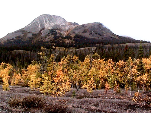
The Autumn scenery was other worldly. I felt lucky to be there on Sept. 11th.

A few hours in I ran into this river crossing:

In the Fall water levels should be very low. … Right?
I backtracked to a ridge and relaxed watching 3 other hikers try to find the best place to cross.

Eventually (tiring of that entertainment) I set up my tent and took an afternoon nap in the bright sunshine.

My Slim’s River hike was over. I wouldn’t make it to the Kaskawulsh Glacier.
Next day I returned to my vehicle early, on to more Yukon adventures.
more photos – hiking Slim’s River West, Yukon (A’äy Chù)