… a grand feat of engineering linking the remote and isolated communities of Puerto Montt in the north with Villa O’Higgins in the south. Perhaps a curiouser byproduct is that of the adoption of this rough isolated road spanning 1200 kms by cyclists. Voted one of the top ten cycling destinations in the world, each year more and more come to make their pilgrimage to the holy grail of adventurous cycling. …
Two filmmakers, Jennifer Jordan and Jeff Roads, are working on a documentary that delves back into the Greg Mortenson story. Their film is called 3000 Cups of Tea (see trailer below), and it is nearing completion. They say they have a very different side of the story to tell, and that their experience with Central Asia Institute, and Mortenson’s work, does not resemble what 60 Minutes reported. They have visited many of the schools that were the result of Greg’s work, and they say that aside from a few that aren’t up and running, most of them are serving the purpose that their founder intended. …
I stopped by the 68 metre freefall not one bit interested in trying it myself.
17 February 2012 | Nicolene Smalman:
Hefty fines have been imposed on the company that owns the Big Swing, and two employees who managed the tandem jump in which Ms Jo-Anne Samuels was killed on October 3, 2009. She undertook the jump with her husband, Capt Hendrik Samuels.
The couple plummeted to the bottom of the gorge of about 60 metres, where they struck a rock at great speed. …
I would have loved to trek famed multi-day Fanie Botha Trail in South Africa.
But the best I could do was to day hike sections:
• Lone Creek Falls
• Bridal Veil Falls
• Mac Mac Falls
• Mac Mac Pools
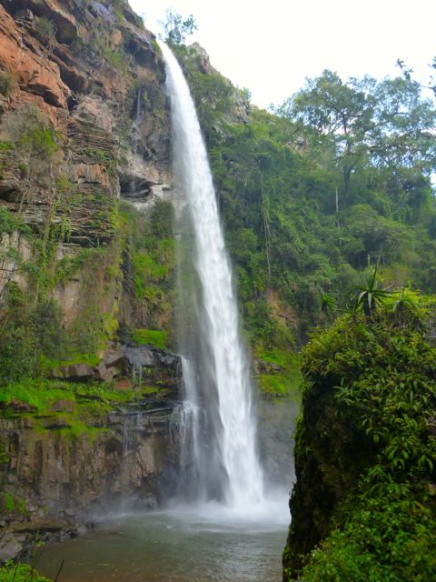
Lone Creek Falls, a National monument, is yet another of the dozens of impressive waterfalls close to Graskop, South Africa.
Nearby are the equally impressive, but much more popular, Bridal Veil Falls.
I parked at Ceylon Hut on the Fanie Botha, then ran to Bridal Veil. The trail here is signed for mountain bikes, as well.
From the base of the falls, there’s a rough scramble up the escarpment. Scenic and challenging.
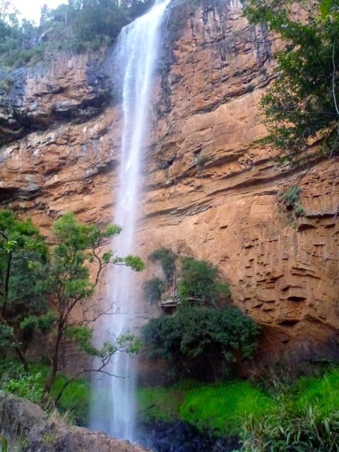
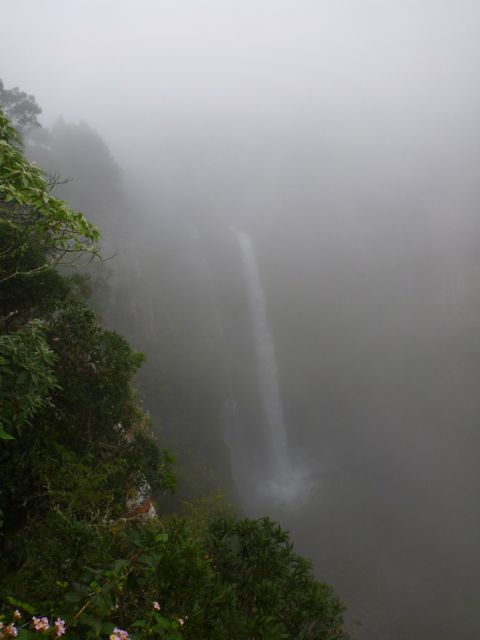
Mac Mac Falls is another National monument. I’d been warned the weather here is often misty and/or rainy. But this was the only day I got the typical slogging in the fog.
Parking at Mac Mac Falls, I hiked both directions on the Fanie Botha. Towards President Burger Hut (… yep, that’s the real name) is was mellow forest trail.
Towards Graskop Hut you walk the top of a cliff. It must be very scenic, when the clouds are not so low.
A wonderful hike – well maintained, easy to follow, varied, great facilities and they even gave me the best possible weather without a drop of rain in the middle of the rainy season but the most remarkable thing was I didn’t see ONE other person on the entire trail…?
115km of hiking
3 days and 3 nights
Over 2500m of elevation gain …
Mix of mountains, rain forest, waterfalls, pools, ridges, creeks, pine plantations, long grasses and more!
Starting/end point: the town of Sabie (few hundred kms from Jo’burg and Pretoria in NE South Africa) …
Starting points are either at the Ceylon Hut (on Ceylon Plantation), or the President Burger Hut (at Mac Mac Forest Retreat), or the Graskop Hut (near the town of Graskop) and parking is available at these points only.
It’s easy to section hike the Fanie Botha, especially with those big loops.
Maritzbos circular three night trail, total distance 30.1 km
Bonnet/Mac Mac Pools two day trail, total distance 39 km
Hartbeesvlakte two night trail, total distance 30.1 km
Mount Moodie/y four night trail, total distance 58.8 or 49.5 km
Fanie Botha five night trail, total distance 71.8 or 62.5 km
Go magazine has a terrific trip article by Anim van Wyk and photographer Lawrette McFarlane:
Opened in 1973, the Fanie Botha Hiking Trail between Sabie and Graskop is the first formally designated trail in the country. …
Be careful on the bridge over the Mac-Mac River in the rain – it’s very slippery.
You hike past the spectacular Mac-Mac Falls – a national monument – on Day 5.
Who was Fanie Botha?
In the 1960s, one Paul van Zyl did a master’s degree on the Appalachian Trail in the United States of America – a trail that stretches over 3500 km in the east of the country. On his return to South Africa he convinced Fanie Botha, then minister of forestry, that hiking trails were a way to make better use of plantations.
Botha’s plan was to develop one long trail from the Soutpansberg all along the escarpment to the Cederberg in the Western Cape. This dream was never realised.
On 11 and 12 May 1973, about 30 hikers hiked the 45 km from the Lone Creek Falls over Mount Anderson to the Mac-Mac Falls, where Botha then officially opened the trail.
Botha promulgated legislation for the national hiking trail system and enabled the establishment of the National Hiking Trail Council in 1975. He could be called “the father of hiking” in South Africa.
There are four huts on the trail:
Ceylon Hut. This was the name of one of the first plantations in the former Transvaal.
Maritzbos Hut. It’s named after the Maritz family to which this piece of land once belonged. They felled trees to make supports for mine shafts.
Stables Hut. It used to be a mule stable. Mules are still used to drag out felled trees.
President Burgers Hut. It’s named after the president of the ZAR between 1872 and 1877.
EVERYONE drives South Africa’s Blyde canyon highways carefully, dodging potholes. Yet EVERYONE stops at the Bourke’s Luck Potholes:
Sustained kolks in the Treur River’s plunge pools have eroded a number of cylindrical potholes or giant’s kettles, which can be viewed from the crags above. It was named after a local prospector, Tom Bourke, who predicted the presence of gold, though he found none himself. The pedestrian bridges connect the various overlooks of the potholes and the gorge downstream. …
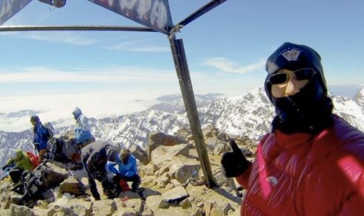
My hiking partner from Manaslu last year is in Patagonia.
He got some (rare) good weather at Fitzroy.
Mike Howarth:
Riding in to El Chalten there before me stood the Fitzroy massif bathed in sunlight. Monte Fitzroy, Cerro Torre, Poincenot, Inominata and many more …
After two days of fine weather, clear views of Fitzroy and Cerro Torre my business here is done. Autumn begins and its time to head north and begin the next leg of the journey; The Carretera Austral.